
Country United States County Island Area code(s) 360 Elevation 23 m Population 1,849 (2013) | Time zone Pacific (PST) (UTC-8) FIPS code 53-15185 Zip code 98239 Local time Tuesday 4:30 AM | |
 | ||
Weather 3°C, Wind SE at 21 km/h, 80% Humidity | ||
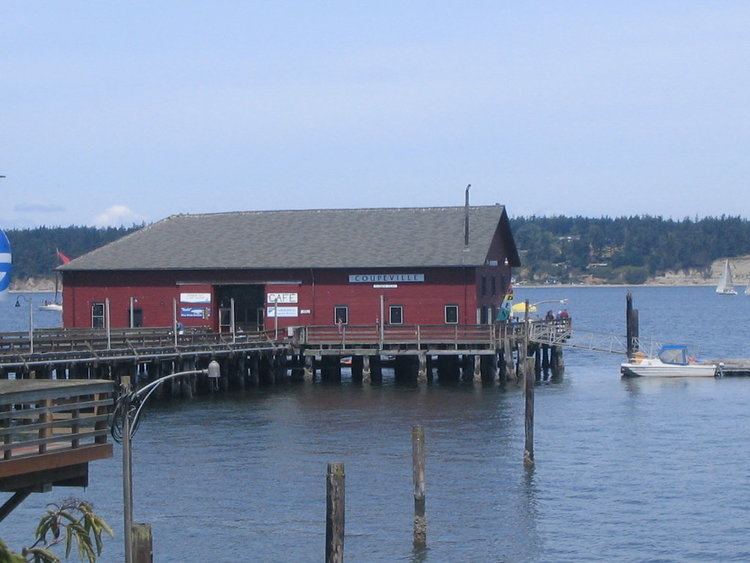
Coupeville is a town on Whidbey Island, in Island County, Washington, United States.
Contents
Map of Coupeville, WA 98239, USA
It is the county seat of Island County. The population was 1,831 at the 2010 census.
History
Coupeville was laid out in the 1850s by Captain Thomas Coupe, and named for him.
Coupeville was officially incorporated on April 20, 1910.
Coupeville is a historic district is within the federal Ebey's Landing National Historical Reserve. The reserve was established by Congress in 1978, as the first and now one of the largest National Historical Reserves in the nation. Its 22 square miles (57 km2) also encompass farmlands, Fort Ebey State Park, Fort Casey State Park, shorelines and beaches, parks, trails, and 91 buildings and structures on the National Register of Historic Places.
Geography
Coupeville is located at 48°13′6″N 122°41′1″W (48.218250, -122.683556).
According to the United States Census Bureau, the town has a total area of 1.23 square miles (3.19 km2), all of it land.
Climate
Coupeville experiences significantly lower rainfall than much of western Washington, due to its location within rainshadow of the Olympic Mountains. Due to the significant drying trend in summer, Coupeville's climate is classified as warm-summer Mediterranean, according to the Köppen climate classification system.
2010 census
As of the census of 2010, there were 1,831 people, 806 households, and 428 families residing in the town. The population density was 1,488.6 inhabitants per square mile (574.8/km2). There were 933 housing units at an average density of 758.5 per square mile (292.9/km2). The racial makeup of the town was 87.2% White, 1.6% African American, 0.6% Native American, 1.9% Asian, 0.3% Pacific Islander, 4.2% from other races, and 4.3% from two or more races. Hispanic or Latino of any race were 9.0% of the population.
There were 806 households of which 21.1% had children under the age of 18 living with them, 42.8% were married couples living together, 7.3% had a female householder with no husband present, 3.0% had a male householder with no wife present, and 46.9% were non-families. 40.0% of all households were made up of individuals and 19.4% had someone living alone who was 65 years of age or older. The average household size was 2.06 and the average family size was 2.77.
The median age in the town was 51.1 years. 17.1% of residents were under the age of 18; 6.3% were between the ages of 18 and 24; 19.1% were from 25 to 44; 29.9% were from 45 to 64; and 27.5% were 65 years of age or older. The gender makeup of the town was 44.3% male and 55.7% female.
2000 census
As of the census of 2000, there were 1,723 people, 737 households, and 426 families residing in the town. The population density was 1,346.7 people per square mile (519.7/km²). There were 814 housing units at an average density of 636.2 per square mile (245.5/km²). The racial makeup of the town was 89.79% White, 1.57% African American, 0.52% Native American, 2.15% Asian, 2.84% from other races, and 3.13% from two or more races. Hispanic or [Latino of any race were 5.34% of the population.
There were 737 households out of which 25.5% had children under the age of 18 living with them, 46.0% were married couples living together, 9.1% had a female householder with no husband present, and 42.1% were non-families. 36.9% of all households were made up of individuals and 19.4% had someone living alone who was 65 years of age or older. The average household size was 2.16 and the average family size was 2.81.
In the town, the population was spread out with 21.1% under the age of 18, 6.0% from 18 to 24, 25.0% from 25 to 44, 22.7% from 45 to 64, and 25.2% who were 65 years of age or older. The median age was 43 years. For every 100 females there were 83.5 males. For every 100 females age 18 and over, there were 81.2 males.
The median income for a household in the town was $33,938, and the median income for a family was $47,721. Males had a median income of $33,235 versus $27,100 for females. The per capita income for the town was $18,720. About 8.9% of families and 11.4% of the population were below the poverty line, including 14.9% of those under age 18 and 8.2% of those age 65 or over.
Economy
In 1987, 42 percent of the county's population were employed by the military. Major employers in Coupeville are Island County and Whidbey General Hospital.
Service and retail businesses serve the island population and visitors attracted to the town's historic waterfront district and Ebey's Landing National Historical Reserve. Retail businesses are located along North and South Main Street, Coveland, and Front Street along the waterfront. In addition to 11 restaurants, cafes, and coffee shops, stores include art galleries, gourmet food, clothing, souvenir, and home decor retailers. With few exceptions, these businesses are operated by individual local owners.