
Length 57.23 km | ||
 | ||
West end: CR 571 in West Windsor Township Counties | ||
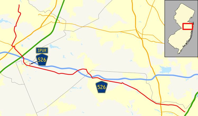
County Route 526, abbreviated CR 526, is a county highway in the U.S. state of New Jersey. The highway extends 35.56 miles (57.23 km) from Hightstown Road (CR 571) in West Windsor Township to Lanes Mill Road (CR 549) in Lakewood Township.
Contents
Map of Co Rte 526, Freeburg, MO 65035, USA
Despite the official ending at County Route 571 in West Windsor, most signs show it concurrent with 571 to its end at state Route 27 in Princeton.
Route description
CR 526 officially begins at an intersection with CR 571 in West Windsor Township, Mercer County, heading south on two-lane undivided New Edinburg Road. Although the official western terminus is here, signage for CR 526 continues northwest along CR 571 to Route 27 in Princeton. From CR 571, the route passes through residential subdivisions, curving east and then south onto Hightstown Road with a wide painted median. The road crosses CR 644 and continues south, with the center line narrowing past the New Village Road intersection. CR 526 intersects CR 535 and CR 641, turning west for a brief concurrency with CR 535 on Old Trenton Road before heading south on Robbinsville Road. The route into agricultural areas and enters Robbinsville Township, eventually heading into a mix of farms, woods, and homes. Farther south, the road passes through housing subdivisions before turning southeast for a brief concurrency with Route 33 prior to following Robbinsville-Allentown Road. Here, CR 526 passes businesses and crosses an abandoned railroad line before coming to US 130. The route turns northeast for a brief concurrency with US 130 on a four-lane divided highway before resuming east on two-lane undivided Robbinsville-Allentown Road. The road curves south and then southeast as it heads into residential areas. CR 526 passes over the New Jersey Turnpike (I-95) before turning south near warehouses and coming to an interchange with I-195. South of this interchange, the route heads through a mix of farmland and woodland, curving southeast.
CR 526 continues into Allentown in Monmouth County and passes homes before it forms a short concurrency with CR 524 and CR 539 on Main Street. From this point, the route continues east through residential areas on Waker Avenue, leaving Allentown for Upper Freehold Township. In this area, the road passes farms to the north and homes to the south as it intersects CR 526 Spur. CR 526 heads through a mix of farmland and woodland with a few areas of development, passing through open areas of farms prior to crossing CR 43, which loops to the south of CR 526 and intersects it again a short distance later. The route passes agricultural areas to the north and woodland to the south before running through a mix of farms, woods, and residences. The road passes Red Valley Lake and heads into Millstone Township, becoming Trenton-Lakewood Road and turning to the northeast. CR 526 passes over I-195 and curves east into more wooded areas before intersecting CR 571 again in developed areas. At this point, CR 526 turns south to run concurrent with CR 571, passing through forested areas with a few homes.
Upon crossing CR 537, the road enters Jackson Township in Ocean County and continues through more forests, passing under I-195 before CR 526 splits from CR 571 by turning east onto West Commodore Boulevard. The road passes through more wooded areas of development, with the forests becoming more dense as the route comes to CR 527. At this intersection, CR 526 becomes East Commodore Boulevard and passes near more forested areas of homes before briefly joining CR 638 and becoming Jackson Mills Road. The road passes through wooded areas with some farms and development, with the road name changing to County Line Road. CR 526 heads southeast into increasing residential and commercial development as it widens into a four-lane divided highway with jughandles as it approaches the CR 636 junction. The route passes several businesses before becoming the border between Jackson Township to the northeast and Lakewood Township to the southwest as it intersects CR 641 and becomes a four-lane undivided road. The road heads into more residential surroundings as it fully enters Lakewood Township, intersecting CR 639 before curving to the east and coming to the US 9 junction. Past this intersection, CR 526 narrows to two lanes and passes more homes as it heads to the CR 547 junction. The route crosses Conrail Shared Assets Operations' Southern Secondary line and passes more areas of homes and businesses before entering morw wooded areas of development and turning southeast to meet CR 623. At this point, the name of the road changes to Lanes Mill Road and it passes more residential areas before CR 526 comes to its eastern terminus at CR 549.
CR 526 Spur
County Route 526 Spur is a county highway in the U.S. state of New Jersey. Entirely within Upper Freehold Township, it is known as the Allentown Bypass, as it allows through traffic to bypass the Borough of Allentown. The highway extends 0.44-mile (0.71 km) from Allentown - Red Valley Road (County Route 526) to Old York Road (County Routes 524 and County Route 539).