
South end: MN 61 in Grand Marais Counties: Cook County Cook County, Minnesota Major cities Grand Marais | North end: Near Saganaga Lake Length 91.1 km Highway system US county highway | |
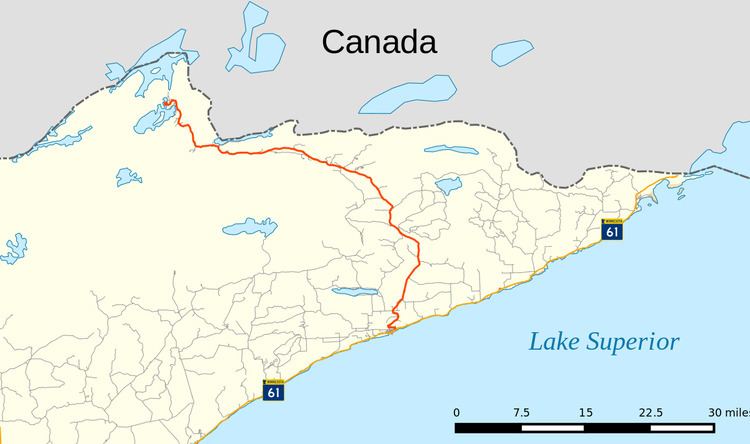 | ||
County Road 12, also known as the Gunflint Trail, or County State-Aid Highway 12, is a 57-mile (92 km) paved roadway in Cook County, Minnesota, that begins in Grand Marais and ends at Saganaga Lake in the Boundary Waters Canoe Area Wilderness (BWCA), near the U.S. border with Ontario. It provides access to many of the entry points in the BWCAW.
Contents
- Map of Gunflint Trail Grand Marais MN 55604 USA
- Route description
- Ham Lake Fire
- Geography and tourism
- Flora and fauna
- References
Map of Gunflint Trail, Grand Marais, MN 55604, USA
Route description
Originally a foot path for travelers from inland lakes to Lake Superior, the trail was eventually widened into a roadway, and designated as County Road 12 (CR 12). It now serves as a route to lodges, outfitters, hiking trails and the lakes and rivers of the BWCA. A small number of people, numbering in the hundreds, have full-time residences or businesses along the road, though thousands have cabins or other part-time residential properties.
Ham Lake Fire
The Ham Lake Fire of spring 2007 severely impacted the Upper Gunflint Trail, burning over 40,000 acres (160 km2) in the Boundary Waters Canoe Area and Ontario's Quetico Provincial Park. The fire lasted several weeks and claimed almost 200 structures, although no one was seriously injured or killed. It was started accidentally by an unattended campfire at a campsite on Ham Lake. The fire drew national attention and a visit from Governor Tim Pawlenty, who inspected the damage first-hand. Despite the significant damage to the forest, most outfitters and commercial businesses have reopened and access to the region's lakes has resumed.
Geography and tourism
Glaciers created the area's geographical features, forming basins running east to west with the region's bedrock, and when they retreated, lakes formed. The Ojibwa and French explorers found chert, which produces sparks, at Gunflint Lake and gave the trail its name, In contemporary times, both fire and wind put stress on the area.
The Ojibwa built a village that is now Grand Marais, which became a trading post and a center for logging and commercial fishing. The town today is home to artists and artisans, and tourists who visit for the Gunflint Trail's canoe routes, hiking, fishing and 120 miles (193 km) of trails for cross-country skiing.
In the summer, the Gunflint Trail community is a hub of activity for campers, canoeists, hikers and fishermen. Several famous establishments can be found along the trail, including the historic Gunflint Lodge, the Trail's End Cafe, and Trail Center restaurant. There are also many outfitters for canoe trips into the BWCA, campsites, homes and several camps, including Adventurous Christians, Gunflint Wilderness Camp, and Wilderness Canoe Base.
Flora and fauna
Grouse, white-tailed deer, black bear, moose, fox, snowshoe hares, wolves, lynx and pine marten inhabit the surrounding forest which comprises spruces, fir, pines, birch and aspen. Lake trout, walleye, northern pike, and bass inhabit the many lakes along the Gunflint Trail.