
Country Canada City Markham Area code(s) 905 and 289 | Regional municipality York Time zone EST (UTC-5) Province Ontario | |
 | ||
Weather 0°C, Wind E at 14 km/h, 69% Humidity | ||
Cornell is a new community village being developed in northeast Markham, Ontario and bounded by Highway 407, 16th Avenue, Ninth Line, and the Don Cousens Parkway. The 2011 population of this area was 9,880. Adding Cornell North's 2,178 (from 16th Avenue to Don Cousens Parkway) it had 12,058 residents.
Contents
History
Cornell was conceived in the 1990s planning process by the town of Markham. Unlike other Markham communities, Cornell is a planned community.
One of the original settlers was Christian Reesor. He and his family settled in Cornell. Their original homestead was on Reesor Road. The name ‘Cornell’ derives from the maiden name of the wife of Christian Reesor’s youngest son, who continued to live at the family homestead.
William Cornell
Cornell's name was selected in the 1990s from a suggestion by local lawyer Paul Mingay. Mingay's family roots can be traced back to Susan Emily Cornell, a descendant of William Cornell (1766-1860), settler from Rhode Island who came to Canada in 1799 and settled in Scarborough, Ontario in 1800. Later Cornells settled in Markham, Ontario and married into the Reesor family. William Cornell immigrated to Canada from Rhode Island and is a distant relative of Ezra Cornell, founder of Cornell University.
Community description
Most of the houses are townhomes, semi-detached, or detached houses with garages at the rear. The communities are built with central amenities in order to contain suburban sprawl. Cornell was seen by the Markham Town Council as a way to deter the ongoing sprawl by encouraging residential density. The community, particularly Cornell Village, is designed as a walkable neighborhood with a variety of housing types and retail. Cornell Village, between Highway 7 and 16th Avenue, is fully populated with medium density residential. The southern section of Cornell (south of Highway 7), however, is not populated, and remains as a wild field and a farm. In 2012, the City of Markham completed Fire Station 99 to serve the area.
Subdivisions within Cornell
Cornell can be further separated by development phases:
The remaining portions of Cornell are still non-agricultural grasslands, but it will slowly disappear with further development.
In 2004 there was a plan to create a residential and retail development called Cornell Town Centre along the southern end of Cornell. This plan never materialized and most of the area has since been re-developed as residential homes. The man-made recreational Cornell Lake is now a series of ponds that carries the waters of Little Rouge Creek in Grand Cornell development.
Air
This area is mainly served by Toronto Pearson International Airport for civilian air travel.
The development is not far from the proposed Pickering Airport and once one of the sites for landfills in the Greater Toronto Area. While runway 10R/28L will still be within Pickering, the southwest end of the property will be located north of 16th Avenue and 9th Line.
Toronto/Markham Airport is located north in Dickson Hill, Ontario is a privately owned general aviation airfield.
Public transit
Transportation links to the community include GO Transit, and York Region Transit.
The Markham-Stouffville Hospital YRT Terminal temporarily serves Cornell with several YRT routes:
The Markham Stouffville Hospital Terminal is a temporary terminal serving Cornell and the nearby areas. The York Region Transit authority is currently building a permanent bus terminal, Cornell Terminal, located at Donald Cousens Parkway and Highway 7. The temporary terminal at Markham Stouffville Hospital will shut down upon completion of the new terminal. The plans for the new terminal may include connections with Durham Region Transit. The completion date is not yet to be known.
There is also one VIVA line serving the area, Viva Purple. Viva Purple terminates at the Markham Stouffville Hospital as well, with plans in the future stretching to Cornell Terminal.
Road
Major roads and highways in the community include:
Arterial roads
Secondary roads
Highways
The above roads are heavily travelled by commuters during the weekdays to get around Markham, York Region and down to Toronto.
Parks and recreation
A number of smaller parks dot the area and do not have any names. City owned parks are maintained by parks staff year round.
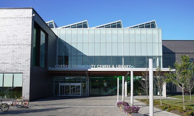
Cornell Community Centre
Cornell Community Centre is the City's newest community centre featuring a library, community rooms and an indoor swimming pool