
Population 4,639 (2011 census) Time zone AEST (UTC+10) Postal code 2315 | Postcode(s) 2315 Area 3.1 km² Local time Monday 11:02 PM | |
 | ||
Location 205 km (127 mi) NNE of Sydney58 km (36 mi) NE of Newcastle44 km (27 mi) ENE of Raymond Terrace Weather 21°C, Wind S at 32 km/h, 65% Humidity Points of interest Port Stephens Shell Museum, Bagnalls Beach Reserve, Bagnalls Beach | ||
Corlette is a suburb of the Port Stephens local government area in the Hunter Region of New South Wales, Australia. It is located just west of Nelson Bay on the shores of Port Stephens. It was named after Captain James Corlette who skippered the 63 tonnes (62 long tons) cutter Lambton which was the first privately owned local vessel. The Corlette was first used to ship timber and wool out of Port Stephens in 1816. While property values throughout the suburb average around A$475,000, in the most affluent areas on the shores of Salamander Bay individual sale prices of $3.7 million have been realised.
Contents
Map of Corlette NSW 2315, Australia
Geography
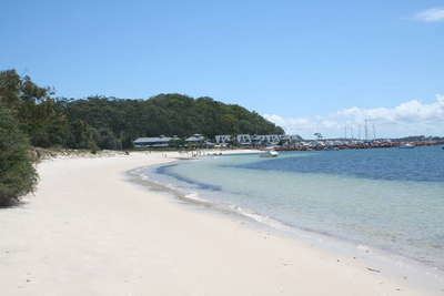
Corlette is located on the southern shores of Port Stephens with approximately 75% of the suburb's 4.3 kilometres (2.7 mi) of coastline being occupied by three beaches. Its western border forms the shoreline of Salamander Bay, after which the adjoining suburb of Salamander Bay is named. On its northern shoreline are two beaches. The largest of these, Bagnalls Beach, gives its name to a large housing estate within the suburb.