
Country Philippines Province Romblon Settled 1574 Area 28.53 km² Population 10,283 (2015) | Region MIMAROPA (Region IV-B) District Lone district Barangays Local time Monday 4:20 PM Area code 42 | |
 | ||
Weather 27°C, Wind N at 14 km/h, 74% Humidity | ||
Corcuera is a fifth class municipality located on Simara Island, in the province of Romblon, Philippines. It was named after the Spanish governor-general Sebastián Hurtado de Corcuera who ruled the Philippines from 1635 to 1644 on behalf of King Philip IV of Spain.
Contents
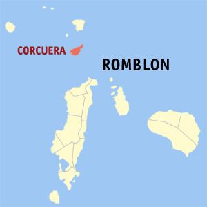
- Map of Municipality of Corcuera Romblon Philippines
- Early history
- Modern history
- Geography
- Barangays
- Demographics
- Local government
- Economy
- Transportation
- Tourism
- References
Map of Municipality of Corcuera, Romblon, Philippines
Early history
The island’s name, Simara, was derived from the local word sima, meaning "hook", which refers to how the island looks like. Corcuera was originally established as San Jose by the Spanish in 1574. In 1621, Augustinian Recollect missionaries arrived in the island and converted the locals into Christianity. By 1726, a stone church dedicated to Saint Joseph was built through the initiative of Fr. Agustin de San Pedro, also known as El Padre Capitan. He also ordered the construction of a watchtower in Tacasan which will serve as a lookout and warning for the locals of impending Muslim raids which plagued the province at that time.
Modern history
In 1910, during the American colonization period, the town was visited by the American survey ship Fathomer which conducted hydrographic surveys and depth sounding in the waters around Simara Island. Its American crew also constructed a lighthouse which is still standing today. At that time, Corcuera was still administered as part of Banton municipality on nearby Banton Island. In January 1931, Corcuera was granted local autonomous government by virtue of Chief Executive Order No. 292, Series of 1930 initiated by then Governor Manuel T. Albero. Corcuera then became the third island municipality in the province. The inauguration of Corcuera as a maiden municipality was held on February 3, 1931.
During World War II, the Japanese established a garrison at Tanro-aw Hill in the island. On March 10, 1945, American and Filipino soldiers who were liberating the Philippines from Japanese occupation launched a task force from Mindoro to liberate the islands of Romblon and Simara. On March 12, elements from Companies B and C of the 19th Infantry, 24th Division of the US 8th Army landed in Simara led by 1st Lt. David B. Bernard. They were assisted by the USS Haas, skippered by Lt. Cmdr. A. M. White.
After four days of mortar and naval bombardment and heavy fighting, the Americans were able to subdue the Japanese in Tanro-aw and liberate the island. The fighting left 118 Japanese, 10 Americans, and one Filipino dead.
As separate district from Capiz*
As fully pledged politico-military province**
Province established by US civilian government***
Geography
Corcuera has a total land area of 23.40 km2. It is hemmed in by bodies of water from all sides: on the north and east by the Sibuyan Sea; on the south and east by Tablas Strait. It is a hilly, volcanic island with many hot springs, while stretches of flat land lie along its northern coast.
Barangays
Corcuera is politically subdivided into 15 barangays.
Demographics
According to the 2015 census, it has a population of 10,283 people. Majority of this population speak the vernacular Asi language, which is also spoken in Banton, Concepcion, Calatrava, and Odiongan. The island's inhabitants are predominantly Roman Catholic, with a small number of Protestants, Iglesia ni Cristo, and Jehovah's Witnesses.
Local government
Pursuant to Chapter II, Title II, Book III of Republic Act 7160 or the Local Government Code of 1991, the municipal government is composed of a mayor (alkalde), a vice-mayor (bise alkalde) and members (kagawad) of the legislative branch Sangguniang Bayan alongside a secretary to the said legislature, all of which are elected to a three-year term and are eligible to run for three consecutive terms.
The mayor of Corcuera is the municipal executive of the town. The incumbent mayor and vice-mayor are Rachel M. Bañares and Elmer M. Fruelda, respectively, both from the Nacionalista Party.
Economy
Corcuera has a primarily agricultural economy, with rice and copra farming, as well as fishing, as the main sources of livelihood. There is also an indigenous raffia palm handicraft industry. Other crops grown in the island are root crops (such as cassava, sweet potatoes), fruits and vegetables. The locals also engage in livestock raising for local consumption.
Transportation
As seas surrounding Corcuera can be rough during the wet season, the best time to visit the island is from March to May during the dry (summer) season. This is also the typical time for Asi families living in Metro Manila or abroad to visit the island since it coincides with the Lenten season and barangay fiestas.
Within the island, the main forms of transportation are passenger motorcycles (known elsewhere as habal-habal) and motorized boats. A circumferential road connects the 15 barangays of Corcuera to each other.
Tourism
Corcuera boasts of fantastic natural beauty and rich historical and cultural heritage. Some of the places worth seeing in the island include: