
Country United States FIPS code 26-17840 Elevation 240 m Local time Saturday 11:13 PM | Time zone Eastern (EST) (UTC-5) GNIS feature ID 1624472 Population 2,057 (2013) | |
 | ||
Weather -2°C, Wind E at 18 km/h, 63% Humidity Area 4.584 km² (4.17 km² Land / 41 ha Water) University Institut d'Architecture et d'Urbanisme | ||
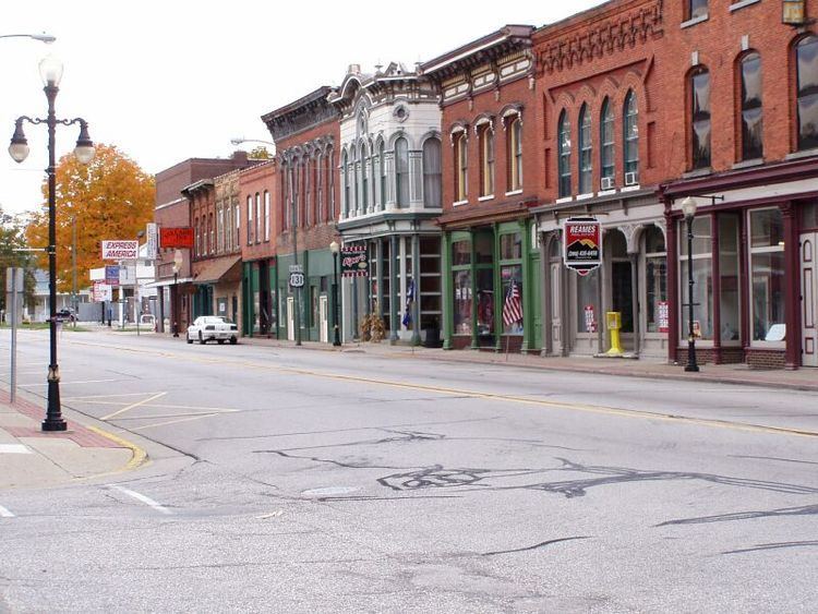
Constantine is a village in St. Joseph County in the U.S. state of Michigan. The population was 2,076 at the 2010 census. The village is located within Constantine Township. It is on U.S. Highway 131, leading to Kalamazoo to the north and to the Indiana Toll Road six miles to the south. The non-navigable St. Joseph River passes through it toward Lake Michigan. The telephone provider is Verizon and the electric provider is AEP Indiana Michigan Power. Constantine is also the Seed Corn Capital of the World with both Monsanto and Pioneer having their biggest facilities located here.
Contents
- Map of Constantine MI 49042 USA
- History
- Geography
- 2010 census
- 2000 census
- Tourism
- Notable people
- References
Map of Constantine, MI 49042, USA
Constantine is the birthplace of Harry Hill Bandholtz, US Brigadier General in World War I and head of the US Military Mission to Hungary.
History
The village was platted in 1831 at the St. Joseph River's confluence with the Fawn River, where three families had settled. Constantine was named for the Roman emperor Constantine the Great. A gristmill, the first in the county to run by water, had been built there in 1830.
Geography
According to the United States Census Bureau, the village has a total area of 1.77 square miles (4.58 km2), of which 1.61 square miles (4.17 km2) is land and 0.16 square miles (0.41 km2) is water.
2010 census
As of the census of 2010, there were 2,076 people, 728 households, and 522 families residing in the village. The population density was 1,289.4 inhabitants per square mile (497.8/km2). There were 829 housing units at an average density of 514.9 per square mile (198.8/km2). The racial makeup of the village was 91.5% White, 1.8% African American, 0.9% Native American, 0.5% Asian, 2.4% from other races, and 3.0% from two or more races. Hispanic or Latino of any race were 3.3% of the population.
There were 728 households of which 45.1% had children under the age of 18 living with them, 47.5% were married couples living together, 18.8% had a female householder with no husband present, 5.4% had a male householder with no wife present, and 28.3% were non-families. 22.7% of all households were made up of individuals and 7.7% had someone living alone who was 65 years of age or older. The average household size was 2.85 and the average family size was 3.27.
The median age in the village was 31.2 years. 31.6% of residents were under the age of 18; 9.3% were between the ages of 18 and 24; 28.2% were from 25 to 44; 22% were from 45 to 64; and 8.9% were 65 years of age or older. The gender makeup of the village was 49.2% male and 50.8% female.
2000 census
As of the census of 2000, there were 2,095 people, 763 households, and 557 families residing in the village. The population density was 1,291.9 per square mile (499.3/km²). There were 836 housing units at an average density of 515.5 per square mile (199.2/km²). The racial makeup of the village was 95.42% White, 0.62% African American, 0.14% Native American, 0.86% Asian, 0.48% from other races, and 2.48% from two or more races. Hispanic or Latino of any race were 1.43% of the population.
There were 763 households out of which 43.5% had children under the age of 18 living with them, 49.9% were married couples living together, 15.2% had a female householder with no husband present, and 26.9% were non-families. 22.5% of all households were made up of individuals and 11.0% had someone living alone who was 65 years of age or older. The average household size was 2.75 and the average family size was 3.12.
In the village, the population was spread out with 32.0% under the age of 18, 9.9% from 18 to 24, 29.7% from 25 to 44, 18.1% from 45 to 64, and 10.3% who were 65 years of age or older. The median age was 30 years. For every 100 females there were 96.5 males. For every 100 females age 18 and over, there were 91.4 males.
The median income for a household in the village was $40,428, and the median income for a family was $44,236. Males had a median income of $35,469 versus $23,152 for females. The per capita income for the village was $15,542. About 14.1% of families and 15.5% of the population were below the poverty line, including 20.9% of those under age 18 and 8.2% of those age 65 or over.
Tourism
John S. Barry, the fourth and eighth Governor of Michigan resided in Constantine. Barry's home, the Governor John S. Barry House, has been listed on the National Register of Historic Places since 1972.