
Length 129 km Source Franklin Township | Source elevation 79 m Mouth Susquehanna River | |
 | ||
Country Carroll County, Maryland and Adams and York Counties, Pennsylvania, United States Main source Franklin Township, Adams County, Pennsylvania
1,440 feet (440 m) River mouth Susquehanna River at York Haven, Pennsylvania
259 feet (79 m) Basin size 515 square miles (1,330 km) | ||
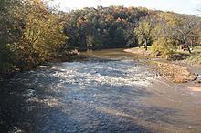
Conewago Creek is an 80.2-mile-long (129.1 km) tributary of the Susquehanna River in Adams and York counties in Pennsylvania in the United States, with its watershed also draining a small portion of Carroll County, Maryland. The source is at an elevation of 1,440 feet (440 m), east of Caledonia State Park, in Franklin Township in Adams County. The mouth is the confluence with the Susquehanna River at York Haven in York County at an elevation of 259 feet (79 m).
Contents
NameEdit
The name of the creek comes from the Lenape, meaning "at the rapids", although the rapids are not on Conewago Creek. Instead, the rapids are the Conewago Falls beyond the creek's mouth in the Susquehanna River, which also give their name to the other Conewago Creek, whose mouth is on the east bank of the Susquehanna River in Dauphin and Lancaster counties, only 1.6 miles (2.6 km) north of the mouth of this Conewago Creek.
CourseEdit
Conewago Creek flows east 39 miles (63 km), then northeast 41 miles (66 km) to its mouth. The source is in Franklin Township in Adams County, and the mouth is at the Susquehanna River at York Haven in York County.
WatershedEdit
The Conewago Creek watershed has a total area of 515 square miles (1,330 km2) and is part of the larger Chesapeake Bay drainage basin via the Susquehanna River. 5.22 square miles (13.5 km2) of the watershed are in Maryland, and the rest is located in Pennsylvania. 50.22% of Adams County is drained by Conewago Creek and its tributaries, while 26.96% of York County is in the creek's watershed.
TributariesEdit
RecreationEdit
Canoeing: Edward Gertler writes that Conewago Creek is "a dull creek.. if you have seen one mile of Conewago, you have seen it all". Canoeing and kayaking on Conewago Creek are possible when the water is high enough (in spring and after hard rain), with 69 miles (111 km) of Class A to Class 1 whitewater located upstream of the mouth.
Fishing: A small section of Conewago Creek in western Adams County has been designated as approved trout waters by the Pennsylvania Fish and Boat Commission. This means the waters will be stocked with trout and may be fished during trout season. Further downstream in Adams County there is a small "catch and release" section of the creek.
Bridges and damsEdit
There are many crossings and dams, some of which are named: