
Source Union Springs | Length 415 km | |
 | ||
Location Pensacola, Florida, Brewton, Alabama, East Brewton, Alabama, Pollard, Alabama, Flomaton, Alabama, Riverview, Alabama | ||
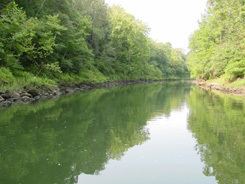
The Conecuh River and Escambia River constitute a single 258-mile-long (415 km) river in Alabama and Florida in the United States.
Map of Conecuh River, United States
The Conecuh River rises near Union Springs in the state and flows 198 miles (319 km) in a general southwesterly direction into Florida near Century. The river's name changes from the Conecuh to the Escambia at the junction of Escambia Creek, 1.2 miles (1.9 km) downstream from the Florida-Alabama line. After this point, the Escambia River flows 60 miles (97 km) south to Escambia Bay, an arm of Pensacola Bay.
The river is dredged in the lower course.
References
Conecuh River Wikipedia(Text) CC BY-SA