
Population 125 (2011) Sovereign state United Kingdom | OS grid reference SP0616 Postcode district GL | |
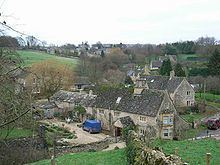 | ||
Compton Abdale is a small settlement in Gloucestershire, England. It is near the A40 road, located on the old 'salt way' which ran across the Cotswolds. The salt was used for curing meat to store for the winter.
Map of Compton Abdale, Cheltenham, UK
In 1870-72, John Marius Wilson's Imperial Gazetteer of England and Wales described Compton Abdale like this: "COMPTON-ABDALE, a parish in Northleach district, Gloucester; on the river Colne, 3 miles WNW of Northleach, and 9 SE by E of Cheltenham r. station. Post town, Northleach, under Cheltenham. Acres, 2, 215. Real property, £2, 047. Pop., 258. Houses, 49. The property is divided among a few. Part of the surface is heath. The living is a vicarage in the diocese of Gloucester and Bristol. Value, £81. Patrons, the Dean and Chapter of Bristol. The church was repaired in 1859."
The Anglican church building, St Oswalds, dates back to the 13th century and features unusual gargoyles. The village is home to The Puesdown Inn - an old coaching inn; and a small stream emerging from some stones called the crocodile.
Most summers the village supports a number of pairs of nesting spotted flycatcher.