
Country United States County Colusa Elevation 15 m Zip code 95932 Local time Wednesday 6:53 PM | State California Incorporated June 16, 1868 FIPS code 06-14946 Area 4.75 km² Population 5,950 (2013) Area code 530 | |
 | ||
Weather 17°C, Wind W at 0 km/h, 62% Humidity | ||
Colusa (formerly, Colusi, Colusi's, Koru, and Salmon Bend) is the county seat of Colusa County, California. The population was 5,971 at the 2010 census, up from 5,402 at the 2000 census. Colusi originates from the local Coru Indian tribe, who in the 1840s lived on the opposite side of the Sacramento River.
Contents
Map of Colusa, CA 95932, USA
Geography
According to the United States Census Bureau, the city has a total area of 1.8 square miles (4.7 km2), all of it land. According to the United States Geological Survey, the city's location is at 39°12′52″N 122°00′34″W.
Colusa is on the Sacramento River, which has a high levee so that the river is not clearly apparent from the city.
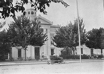
Colusa features a historic Chinatown, Carnegie Library building constructed in 1905, and an architecturally noteworthy courthouse built in a classical style, among its historically notable buildings.
Climate
According to the Köppen Climate Classification system, Colusa has a warm-summer Mediterranean climate, abbreviated "Csa" on climate maps.