
Country United States Largest city Columbia Lowest elevation 0 ft (0 m) | State(s) Missouri Highest elevation N/A ft (N/A m) | |
 | ||
Other cities - Moberly
- Mexico
- Centralia | ||
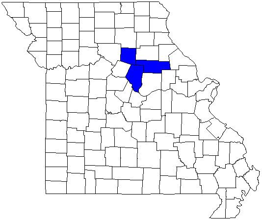
The Columbia metropolitan area or Greater Columbia is a region with cultural and economic ties to Columbia, Missouri a city of 113,225 people. Boone County makes up the immediate Metropolitan statistical area while the addition of Audrain County and Randolph County form the Combined Statistical Area giving the area a population of 223,676 in 2014. The largest cities outside Columbia are Moberly, Mexico, Centralia, Vandalia and Ashland. The University of Missouri has a strong presence in the region. Interstate 70, and U.S. Highways 63, 54, 24, and 40 link the urban areas. The Missouri River forms the southwest border of the region.
Contents
Current
Former
Cities with greater than 100,000 inhabitants
Cities with greater than 10,000 inhabitants
Towns with greater than 1,000 inhabitants
Towns with greater than 100 inhabitants
Villages
Unincorporated places
Demographics
As of the census of 2000, there were 145,666 people, 56,930 households, and 34,010 families residing within the MSA. The racial makeup of the MSA was 85.83% White, 8.42% African American, 0.41% Native American, 2.76% Asian, 0.03% Pacific Islander, 0.67% from other races, and 1.87% from two or more races. Hispanic or Latino of any race were 1.72% of the population.
The median income for a household in the MSA was $34,550, and the median income for a family was $45,689. Males had a median income of $29,837 versus $22,970 for females. The per capita income for the MSA was $17,521.