
Country United States FIPS code 40-16400 Elevation 449 m Zip code 73021 Local time Thursday 2:26 AM | Time zone Central (CST) (UTC-6) GNIS feature ID 1091583 Area 230 ha Population 137 (2013) Area code 405 | |
 | ||
Weather 13°C, Wind SE at 14 km/h, 80% Humidity | ||
Colony is a town in northeastern Washita County, Oklahoma, United States. The population was 136 at the 2010 U.S. census, a decrease of 7.5 percent from 147 in 2000. It was named for the Seger Colony, founded in 1886, which taught modern agricultural techniques to the Arapaho and Cheyenne tribes that would be resettled in the vicinity. Colony is 16 miles (26 km) east and 4 miles (6.4 km) north of Cordell.
Contents
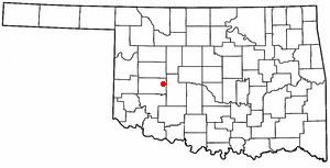
Map of Colony, OK 73021, USA
History
John Seger began a colony for Native Americans with Arapaho Indians, who were joined later by a number of Cheyennes. By the following year, the colony had over 500 inhabitants. Seger began teaching modern agricultural methods as well as brick-making. By 1892, the colony had built an industrial arts school, with the Native Americans providing the bricks and cutting stone for all the buildings.
William De Lestinier opened a store near the school with government permission, even before the Land Run of 1892. After the opening, a group of settlers, led by Zack King, created a townsite 4 miles (6.4 km) west of the school and obtained a post office named Seger. De Lestinier moved his store to the new site. In 1895, the Dutch Reformed Church founded a mission at the colony. In 1896, a new post office named Colony opened, and the town took that name.
Colony continued to grow and had an estimated population of 300 by 1911. The Dutch Reformed mission closed in 1912 and the Seger Indian school closed in 1932.
Geography
Colony is located at 35°21′N 98°40′W (35.3510, -98.6733) in Seger Township (T10N R14W), Washita County, Oklahoma. According to the United States Census Bureau, the town has a total area of 0.9 square miles (2.3 km2), all land.
Demographics
As of the census of 2000, there were 147 people, 64 households, and 49 families residing in the town. The population density was 156.6 people per square mile (60.4/km²). There were 79 housing units at an average density of 84.2 per square mile (32.4/km²). The racial makeup of the town was 80.27% White, 10.20% Native American, 4.76% from other races, and 4.76% from two or more races. Hispanic or Latino of any race were 5.44% of the population.
There were 64 households out of which 28.1% had children under the age of 18 living with them, 71.9% were married couples living together, 4.7% had a female householder with no husband present, and 21.9% were non-families. 20.3% of all households were made up of individuals and 14.1% had someone living alone who was 65 years of age or older. The average household size was 2.30 and the average family size was 2.62.
In the town, the population was spread out with 21.1% under the age of 18, 2.7% from 18 to 24, 21.8% from 25 to 44, 26.5% from 45 to 64, and 27.9% who were 65 years of age or older. The median age was 48 years. For every 100 females there were 96.0 males. For every 100 females age 18 and over, there were 93.3 males.
The median income for a household in the town was $26,912, and the median income for a family was $27,426. Males had a median income of $26,071 versus $16,250 for females. The per capita income for the town was $18,106. There were 15.1% of families and 17.2% of the population living below the poverty line, including 23.5% of under eighteens and 21.6% of those over 64.