
Country United States Settled 1800 Time zone EST (UTC-5) Population 9,521 (2010) University Penn State World Campus | County Centre Incorporated 1857 Area 48.1 km² Local time Wednesday 7:57 PM | |
 | ||
Website www.collegetownship.govoffice.com Weather 11°C, Wind W at 39 km/h, 25% Humidity | ||
College Township is a township in Centre County, Pennsylvania, United States. It is part of the State College, Pennsylvania Metropolitan Statistical Area. The population was 9,521 at the 2010 census, which was a 12.2% increase from the 2000 census. College Township was formed on November 25, 1875 from Howard Township.
Contents
Map of College Township, PA, USA
College Township is served by the State College Area School District for k-12 education and the Alpha Fire Company for fire protection. The Alpha Fire Company maintains of 1 of its 2 substations in the College Township Municipal Building.
Pennsylvania State University is partially in College Township.
History
Two major Native American archaeological sites are located in College Township. Known as the Tudek and Houserville Sites, they were used during the Archaic period for the quarrying and reduction of stone tools made of jasper. Both sites are listed on the National Register of Historic Places.
Geography
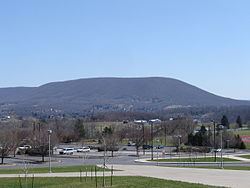
According to the United States Census Bureau, the township has a total area of 18.6 square miles (48.1 km2), all of it land. Mount Nittany is a prominent and well-known feature in the township.
College Township is bordered by Ferguson Township to the west, Patton Township to the northwest, Benner Township to the north, Harris Township to the south and east, and the borough of State College to the south and west.
Demographics
As of the census of 2000, there were 8,489 people, 3,069 households, and 2,050 families residing in the township. The population density was 463.6 people per square mile (179.0/km²). There were 3,213 housing units at an average density of 175.5/sq mi (67.8/km²). The racial makeup of the township was 94.24% White, 1.64% African American, 0.05% Native American, 2.69% Asian, 0.70% from other races, and 0.70% from two or more races. Hispanic or Latino of any race were 1.18% of the population.
There were 3,069 households, out of which 29.7% had children under the age of 18 living with them, 58.8% were married couples living together, 6.2% had a female householder with no husband present, and 33.2% were non-families. 27.9% of all households were made up of individuals, and 11.4% had someone living alone who was 65 years of age or older. The average household size was 2.41 and the average family size was 2.96.
In the township the population was spread out, with 21.1% under the age of 18, 16.7% from 18 to 24, 26.0% from 25 to 44, 21.3% from 45 to 64, and 14.9% who were 65 years of age or older. The median age was 36 years. For every 100 females there were 91.8 males. For every 100 females age 18 and over, there were 89.2 males.
The median income for a household in the township was $50,895, and the median income for a family was $65,649. Males had a median income of $42,617 versus $30,633 for females. The per capita income for the township was $24,163. About 3.9% of families and 6.6% of the population were below the poverty line, including 6.6% of those under age 18 and 4.6% of those age 65 or over.
Government
Federally, College Township is part of Pennsylvania's 5th congressional district, represented by Republican Glenn "G.T." Thompson, elected in 2008.