
Width 2.0 km (1.24 mi) Population Uninhabited | Length 2.7 km (1.68 mi) Highest elevation 450 m (1,480 ft) Elevation 450 m | |
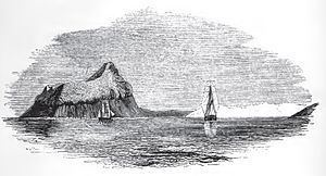 | ||
Cockburn Island is an oval island 2.7 kilometres (1.7 mi) long, consisting of a high plateau with steep slopes surmounted on the northwest side by a pyramidal peak 450 m (1,476 ft) high, lying in the north-east entrance to Admiralty Sound, south of the north-east end of Antarctic Peninsula. It was discovered by a British expedition under Ross, 1839–43, who named it for Admiral George Cockburn, Royal Navy, then senior Lord of the Admiralty.
Contents
Map of Cockburn Island, Antarctica
Geology
Geologically, the area makes up the Cockburn Island Formation, which was studied extensively in the late 1990s by H. A. Jonkers. Rocks found on the island are volcanic, and the island is characterized by its "precipitous cliffs". A "Pecten conglomerate" from the late Pliocene or early Pleistocene period has been identified on the island, situated on a wave-cut platform at 720–820 ft.
Wildlife
The island has been identified as an Important Bird Area (IBA) by BirdLife International because it supports a breeding colony of about 800 pairs of imperial shags. Although a large colony of Adélie penguins and snow petrel nests were reported from the island in 1901, it is not known whether they continue to breed there. J.D. Hooker made a series of botanical collections on the island in 1843.