
- elevation 5,080 ft (1,548 m) - elevation 415 ft (126 m) Basin area 644.9 km² Mouth Sacramento River | - location Girvan - average 211 cu ft/s (6 m/s) Source Damnation Peak | |
 | ||
- right Crystal Creek, Brandy Creek - location Trinity Mountains, Shasta-Trinity National Forest Similar Whiskeytown Lake, WaterWorks Park, Sacramento River Trail, Whiskeytown Dam, Turtle Bay Exploration Park | ||
Clear Creek (Ínaam in Karuk) is a tributary of the upper Sacramento River in northern California.
GeographyEdit
The creek is 60.6 miles (97.5 km) long, flowing in southern Siskiyou County and northern Shasta County. Clear Creek is the first major Sacramento River tributary downstream of the Shasta Dam.
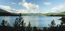
Clear Creek originates in the Trinity Mountains, between Shasta Lake and Trinity Lake in the Shasta-Trinity National Forest, and flows into Whiskeytown Lake reservoir, impounded by Whiskeytown Dam. Past the reservoir, the stream bed continues south until its confluence with the Sacramento River. The Spring Creek Tunnel bypasses that section and delivers water from Whiskeytown Lake directly to Keswick Reservoir, both part of the Central Valley Project.
The site along Clear Creek where Pierson B. Reading discovered gold in 1848 was declared a California Historical Landmark.