
Time zone PST (UTC-8) Elevation 120 m Zip code 94517 Local time Monday 2:30 PM | Incorporated March 18, 1964 FIPS code 06-13882 Area 9.935 km² Population 11,505 (2013) Area code 925 | |
 | ||
Weather 12°C, Wind SW at 16 km/h, 65% Humidity | ||
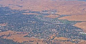
Visit clayton california
Clayton (formerly Clayton's and Claytonville) is a city in Contra Costa County, California, United States. The population was 10,897 as of the 2010 census.
Contents
- Visit clayton california
- Map of Clayton CA USA
- Geography
- Climate
- History
- Education
- Public libraries
- 2010
- 2000
- Media
- References
Map of Clayton, CA, USA
Geography
According to the United States Census Bureau, the city has a total area of 3.8 square miles (9.8 km2), all land.
Clayton is located at the foot of Mt. Diablo State Park.
Climate
This region experiences hot and dry summers. According to the Köppen Climate Classification system, Clayton has a warm-summer Mediterranean climate, abbreviated "Csb" on climate maps.
History
In 1857, the town of Clayton was laid out and founded by Joel Henry Clayton (1812–1872) and his two younger brothers. Clayton was born in Bugsworth, now Buxworth, in the United Kingdom, and emigrated to the United States in 1837. After years in other states he settled down with his wife Margaret (1820–1908) at his town at the foot of Mount Diablo, where he and his family prospered. Clayton was named after Joel Henry Clayton, although only by the flip of a coin. Joel Clayton and Charles Rhine cofounded the town, and each wanted to name it after himself. If Charles had won it would have become Rhinesville, but Joel Clayton won. Joel and his wife Margaret both died in Clayton, and were buried in Live Oak Cemetery in what is now Concord, CA.
Clayton prospered during the coal mining boom in eastern Contra Costa County. The post office opened in 1861. Following a previous incorporation attempt in 1960, Clayton incorporated in 1964 in order to stave off an annexation attempt in 1963 of the Cardinet Glen neighborhood by nearby Concord. After steady expansion during the 1970s to the east and west from its original boundaries, Clayton's land area more than doubled in 1987 to near its present-day boundaries with the annexations of the Dana Hills/Dana Ridge and Clayton Wood subdivisions, as well as the former Keller Ranch property that was developed during the 1990s with the Oakhurst Country Club.
On December 7, 2009, it snowed in Clayton and Concord for the first time since the 1970s.
On September 8, 2013, fire broke out on Mount Diablo. Called the Morgan Fire, it started at the mercury mine area of Morgan Territory Road. The fire grew quickly and threatened homes and livestock. Evacuations were ordered for several areas, including Oak Hill Lane and Curry Canyon. It took over 1000 firefighters and eight aircraft to extinguish it. Full containment was announced on September 14, 2013, having burned 1,259 ha (3,111 acres).
Education
The public schools of which the minors of Clayton attend include: Mt. Diablo Elementary School, Highlands Elementary School, Diablo View Middle School, Pine Hollow Middle School, and Clayton Valley Charter High School.
Public libraries
The Clayton branch of the Contra Costa County Library system is located in Clayton.
2010
The 2010 United States Census reported that Clayton had a population of 10,897. The population density was 2,840.7 people per square mile (1,096.8/km²). The racial makeup of Clayton was 9,273 (85.1%) White, 146 (1.3%) African American, 34 (0.3%) Native American, 717 (6.6%) Asian, 16 (0.1%) Pacific Islander, 234 (2.1%) from other races, and 477 (4.4%) from two or more races. Hispanic or Latino of any race were 982 persons (9.0%).
The Census reported that 10,887 people (99.9% of the population) lived in households, 10 (0.1%) lived in non-institutionalized group quarters, and 0 (0%) were institutionalized.
There were 4,006 households, out of which 1,455 (36.3%) had children under the age of 18 living in them, 2,795 (69.8%) were opposite-sex married couples living together, 301 (7.5%) had a female householder with no husband present, 112 (2.8%) had a male householder with no wife present. There were 136 (3.4%) unmarried opposite-sex partnerships, and 36 (0.9%) same-sex married couples or partnerships. 647 households (16.2%) were made up of individuals and 310 (7.7%) had someone living alone who was 65 years of age or older. The average household size was 2.72. There were 3,208 families (80.1% of all households); the average family size was 3.04.
The population was spread out with 2,662 people (24.4%) under the age of 18, 602 people (5.5%) aged 18 to 24, 2,185 people (20.1%) aged 25 to 44, 3,846 people (35.3%) aged 45 to 64, and 1,602 people (14.7%) who were 65 years of age or older. The median age was 45.0 years. For every 100 females there were 93.4 males. For every 100 females age 18 and over, there were 90.3 males.
There were 4,086 housing units at an average density of 1,065.2 per square mile (411.3/km²), of which 3,621 (90.4%) were owner-occupied, and 385 (9.6%) were occupied by renters. The homeowner vacancy rate was 0.7%; the rental vacancy rate was 3.8%. 9,936 people (91.2% of the population) lived in owner-occupied housing units and 951 people (8.7%) lived in rental housing units.
2000
As of the census of 2000, there were 10,762 people, 3,883 households, and 3,207 families residing in the city. The population density was 1,054.6/km² (2,729.3/mi²). There were 3,924 housing units at an average density of 384.5/km² (995.1/mi²). The racial makeup of the city was 87.95% White, 1.12% Black or African American, 0.19% Native American, 5.38% Asian, 0.10% Pacific Islander, 1.54% from other races, and 3.73% from two or more races. 6.33% of the population were Hispanic or Latino of any race.
There were 3,883 households out of which 39.2% had children under the age of 18 living with them, 74.6% were married couples living together, 5.5% had a female householder with no husband present, and 17.4% were non-families. 13.0% of all households were made up of individuals and 3.9% had someone living alone who was 65 years of age or older. The average household size was 2.76 and the average family size was 3.04.
In the city, the population was spread out with 26.5% under the age of 18, 4.5% from 18 to 24, 28.5% from 25 to 44, 31.5% from 45 to 64, and 9.1% who were 65 years of age or older. The median age was 40 years. For every 100 females there were 96.0 males. For every 100 females age 18 and over, there were 94.6 males.
The median income for a household in the city was $101,652, and the median income for a family was $107,448. Males had a median income of $77,535 versus $50,279 for females. The per capita income for the city was $42,048. About 1.2% of families and 2.6% of the population were below the poverty line, including 3.6% of those under age 18 and 1.9% of those age 65 or over.
Media
The city of Clayton is served by the daily newspaper East Bay Times published by Bay Area News Group-East Bay (part of the Media News Group, Denver, Colorado), and by the local newspapers The Clayton Pioneer, The Clayton Gazette and the Diablo Gazette, and is also served by Claycord.com a local news and talk blog covering community news and events.