
Prominence 472 ft (144 m) | Topo map USGS Church Rock | |
 | ||
Elevation 5,862 ft (1,787 m) NGVD 29 Location Navajo County, Arizona, U.S. | ||
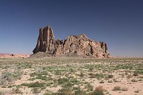
Church Rock is a pillar in Navajo County, Arizona. It is located near the mouth of Church Rock Valley with a summit elevation of 5,862 feet (1,787 m).
Contents
Map of Church Rock, Arizona 86033, USA
History
Church Rock was originally named Artenesales de Piedra or Sculpted Rock, by the Mexican merchant and explorer Antonio Armijo in 1829-1830, when the area was explored by his expedition to find a trade route between Santa Fe de Nuevo México and Alta California. This would become the Armijo Route of the Old Spanish Trail.
References
Church Rock (Navajo County, Arizona) Wikipedia(Text) CC BY-SA