
Country Russia | ||
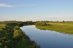 | ||
Chulym (Russian: Чулым) is a river in the endorheic drainage basin of Lake Chany in the southeastern part of the West Siberian Plain in Russia. The river is 392 kilometres (244 mi) long, with a drainage basin of 17,900 square kilometres (6,900 sq mi).
Map of r. Chulym, Novosibirsk Oblast, Russia
The Chulym is formed by several tributaries in the Toyskoye Zaymishche (Russian: Тойское Займище) and Troshinskoye Zaymishche (Russian: Трошинское Займище) swamps north of Baraba Steppe, some 100 kilometres (62 mi) northwest of Novosibirsk, at an elevation of 150 metres (490 ft). The river flows over the Baraba Steppe in a southwesterly direction, and flows through the lakes of Sargul (Russian: Саргуль), 34.6 square kilometres (13.4 sq mi), and Uryum (Russian: Урюм), 84.1 square kilometres (32.5 sq mi), before it finally terminates, at 106 metres (348 ft) elevation, in Malyye Chany Lake (Russian: Малые Чаны – Little Chany), which is connected to Lake Chany through a short strait.
In its lower reaches the river is some 30 metres (98 ft) wide and 5 metres (16 ft) deep. Its main tributaries are the Suma River (left), and the Kargat River (right).
In its upper course is the town of Chulym, named after the river. Here the river is crossed by the Trans-Siberian Railway and the M51 highway.
The Chulym is frozen over from November to April or May.