
ZIP code 85541 Elevation 1,817 m | Time zone MST (UTC−7) Area code(s) 928 Area 7.85 km² | |
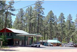 | ||
Christopher Creek is a census-designated place in northern Gila County in the state of Arizona. Situated at the base of the Mogollon Rim, the community lies at an elevation of 5,961 feet (1,817 m), and is located approximately 23.5 miles (37.82 km) northeast of Payson, just off SR 260. The population as of the 2010 U.S. Census was 156.
Map of Christopher Creek, Arizona 85541, USA
Tourism, retirement and timbering are the foundations of Christopher Creek's economy.
References
Christopher Creek, Arizona Wikipedia(Text) CC BY-SA