
Traversed by Trail Range Glarus Alps | Elevation 2,347 m | |
 | ||
Location Uri/Graubünden, Switzerland Topo map Swiss Federal Office of Topography swisstopo Similar Alps, Oberalpstock, Bristen, Piz Giuv, Piz Nair | ||
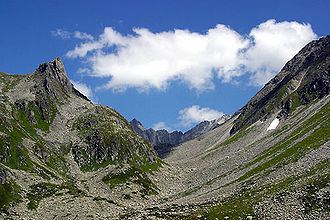
The Chrüzlipass (2,346 m (7,697 ft), Swiss German for Small Cross (as a diminutive) Pass) is a historic high mountain pass of the Glarus Alps, located on the border between the Swiss cantons of Uri and Graubünden (GR). Its connects the Maderanertal (UR) and the Tujetsch (e.g. Sedrun) in Surselva (GR). It is one of the lowest passes between the two cantons and is traversed by a trail.
Map of Chr%C3%BCzlipass, 6475 Silenen, Switzerland
The pass is overlooked by the Witenalpstock and the Chrüzlistock.
Below the Chrüzlipass, or more precisely between it and the Chrüzlistock, runs the Gotthard Base Tunnel.
References
Chrüzlipass Wikipedia(Text) CC BY-SA