
Topo map USGS Chestnut Mountain | Elevation 1,010 m Parent range Blue Ridge Mountains | |
 | ||
Similar Adams Mountain, Flattop Mountain, Grandmother Mountain, Hibriten Mountain, Table Rock | ||
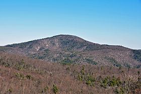
Chestnut Mountain is a mountain in the North Carolina High Country and wholly in the Pisgah National Forest. Its elevation reaches 3,314 feet (1,010 m) and it also marks the corner between Avery, Burke, and Caldwell counties. The mountain generates feeder streams for the Catawba River.
Map of Chestnut Mountain, Wilson Creek, NC 28611, USA
References
Chestnut Mountain (Caldwell County, North Carolina) Wikipedia(Text) CC BY-SA