
Width 0.93 km (0.578 mi) Area 99 ha | Length 1.4 km (0.87 mi) | |
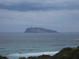 | ||
Chatham Island is located in the South Ward (Walpole) of Manjimup Shire in the Great Southern region of Western Australia. It is approximately 1.1 km (0.68 mi) offshore from D'Entrecasteaux National Park and 3 km (1.9 mi) offshore from Mandalay Beach. Declared a class 1A Nature reserve in 1973, the island has a total area of 106 hectares (260 acres).
Map of Chatham Island, Western Australia, Australia
Named as Cape Chatham by George Vancouver aboard the HMS Discovery in 1791, the island was subsequently renamed as Chatham Island.
References
Chatham Island (Western Australia) Wikipedia(Text) CC BY-SA