
Country United States County Columbia Elevation 239 ft (73 m) Founded 1795 Population 4,128 (2010) | State New York Established 1795 Time zone Eastern (EST) (UTC-5) Zip code 12037 Area code 518 | |
 | ||
Weather -1°C, Wind W at 16 km/h, 33% Humidity | ||
Chatham /ˈtʃætəm/ is a town in Columbia County, New York, United States. The population was 4,128 at the 2010 census.
Contents
- Map of Chatham NY 12037 USA
- History
- Geography
- Adjacent towns and areas
- Demographics
- Communities and locations in the town
- Notable people
- References
Map of Chatham, NY 12037, USA
The town has a village also called Chatham on its south town line. The town is at the north border of Columbia County.
History
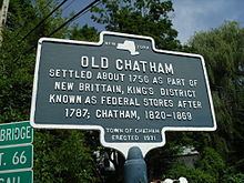
The early settlers were Dutch, but later Quakers and New Englanders arrived. The town of Chatham was formed from the towns of Canaan and Kinderhook in 1795. Contradictory of its current condition or image, Chatham was an industrial center of multiple inter-state rail lines in the early 1900s, including the junction of the Boston and Albany Railroad for connections east and west, the Rutland Railroad for connections to Vermont to the north, and the New York Central's Harlem Line for connections to New York City. In 1887 a terminal designed by Henry Hobson Richardson was constructed. Amtrak service on the Lake Shore Limited passes through, east-west, but does not stop. In later years Amtrak has planned to build a rail station in Chatham.
The Blinn-Pulver Farmhouse, Melius-Bentley House, Peck House, Riders Mills Historic District, Silvernail Homestead, Simons General Store, Spengler Bridge, St. John's Lutheran Church, James G. Van Valkenburgh House, and John S. Williams House and Farm are listed on the National Register of Historic Places.
Geography
According to the United States Census Bureau, the town has a total area of 53.6 square miles (138.7 km2), of which 53.2 square miles (137.9 km2) is land and 0.31 square miles (0.8 km2), or 0.59%, is water.
The north town line is the border of Rensselaer County.
The north end of the Taconic State Parkway is in the town, and Interstate 90 passes through the town.
New York State Route 66 and New York State Route 203 intersect in the town.
Adjacent towns and areas
The town of Kinderhook is to the west, and the towns of Canaan and New Lebanon are to the east. The towns of Schodack and Nassau are to the north in Rensselaer County. The towns of Austerlitz and Ghent are to the south.
Demographics
As of the census of 2000, there were 4,249 people, 1,762 households, and 1,196 families residing in the town. The population density was 79.8 people per square mile (30.8/km²). There were 2,110 housing units at an average density of 39.6 per square mile (15.3/km²). The racial makeup of the town was 96.00% White, 1.74% Black or African American, 0.21% Native American, 0.71% Asian, 0.16% Pacific Islander, 0.16% from other races, and 1.01% from two or more races. Hispanic or Latino of any race were 0.75% of the population.
There were 1,762 households out of which 29.4% had children under the age of 18 living with them, 56.1% were married couples living together, 8.3% had a female householder with no husband present, and 32.1% were non-families. 25.1% of all households were made up of individuals and 8.3% had someone living alone who was 65 years of age or older. The average household size was 2.41 and the average family size was 2.87.
In the town, the population was spread out with 23.5% under the age of 18, 5.7% from 18 to 24, 24.6% from 25 to 44, 33.0% from 45 to 64, and 13.2% who were 65 years of age or older. The median age was 43 years. For every 100 females there were 96.0 males. For every 100 females age 18 and over, there were 93.1 males.
The median income for a household in the town was $49,234, and the median income for a family was $60,097. Males had a median income of $40,067 versus $26,452 for females. The per capita income for the town was $28,599. About 4.8% of families and 6.6% of the population were below the poverty line, including 6.6% of those under age 18 and 4.6% of those age 65 or over.