
Population 2,940 Sovereign state United Kingdom Local time Friday 3:42 PM | OS grid reference SY680927 Postcode district DT | |
 | ||
Weather 10°C, Wind S at 19 km/h, 90% Humidity | ||
Charminster is a village and civil parish in west Dorset, England, situated on the River Cerne and A352 road 1 mile (1.6 km) north of the county town Dorchester. In the 2011 census the parish had a population of 2,940.
Map of Charminster, Dorchester, UK
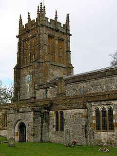
The village name derives from the River Cerne and the small 'minster' church of St Mary, resulting in "Cerneminster" (recorded in 1223), which eventually evolved into Charminster. The village includes Wolfeton House.
Charminster was the English place of origin of Richard Norman and family, one of the Planters of the Massachusetts Bay Colony in America, who arrived there in ca. 1626.
Charminster is in the Charminster and Cerne Valley electoral ward, which stretches from the northern outskirts of Dorchester through Cerne Abbas to Minterne Magna. The total population of this ward at the 2011 census was 4,768.