
Last eruption 980 CE ± 300 years Elevation 2,592 m Volcanic arc Cascade Volcanoes | Mountain type Lava domes Easiest route Scrambling Prominence 177 m | |
 | ||
Similar Mount Tehama, Cinder Cone, Lassen Peak, Bumpass Mountain, Shastina | ||
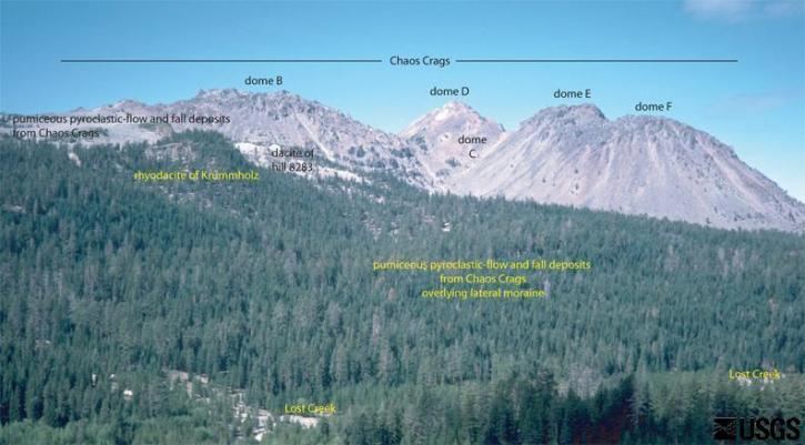
Chaos Crags is the youngest group of lava domes in Lassen Volcanic National Park, California, having been formed as five dacite domes 1,100-1,000 years ago. The cluster of domes is located north of Lassen Peak.
Map of Chaos Crags, California, USA
From the base of the crags and extending toward the northwest corner of the park is Chaos Jumbles, a cold rock avalanche which undermined Chaos Crags' northwest slope 300 years ago. Riding on a cushion of compressed air (see sturzstrom), the rock debris traveled at about 100 miles per hour (160 km/h), flattened the forest before it, and dammed Manzanita Creek, forming Manzanita Lake.
In 1974 the National Park Service took the advice of the USGS and closed the visitor center and accommodations at Manzanita Lake. The USGS stated that these buildings would be in the way of a rockslide from Chaos Crags if an earthquake or volcanic eruption occurred in the area.
In 2011, twenty prefab cabins were reinstalled in the Manzanita Lake Campground. It had been determined in the 1980s that the rockslide danger had been overstated by the USGS, and therefore, the cabins were reintroduced to the park for nightly rental.