
Highest elevation 226 ft (68.9 m) Max length 2.3 km | Max width 201 m | |
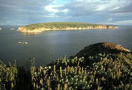 | ||
Chamisso Island is a small island in Kotzebue Sound, Alaska. It is located off Spafarief Bay at the mouth of Eschscholtz Bay, just south of the Choris Peninsula.
Map of Chamisso Island, Alaska, USA
The island is roughly triangular. It is 1.4 miles (2.3 km) long and an 0.125 miles (0.201 km) wide. The highest point on Chamisso Island is 226 feet (68.9 m) above sea level.
Chamisso Island has been a Natural Reserve since December 7, 1912. The protected area, the Chamisso Wilderness, includes Chamisso Island and nearby Puffin Island, as well as some rocky islets nearby. Both islands are part of the Chukchi Sea unit of the Alaska Maritime National Wildlife Refuge.
This island was named after naturalist Adelbert von Chamisso, who reached the island in 1816.
References
Chamisso Island Wikipedia(Text) CC BY-SA