
 | ||
Similar Rainbow Valley Conserva, Palm Valley, Finke River, Finke Gorge National, Corroboree Rock Conserva | ||
Chambers Pillar (Aboriginal name Idracowra or Etikaura) is a sandstone formation some 160 km (100 mi) south of Alice Springs in the Northern Territory of Australia. Erosion by wind and rain has left an isolated pillar of 350-million-year-old sandstone, rising 50 m (160 ft) above the surrounding plain. The rock formation and the surrounding area of 340 hectares, or 3.4 km2 (1.3 sq mi), are officially named the Chambers Pillar Historical Reserve.
Map of Chambers Pillar, Hugh NT 0872, Australia
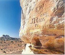
John McDouall Stuart was the first European to see Chambers Pillar, reaching the site in April 1860, and naming it after James Chambers, one of his South Australian sponsors. During the subsequent years numerous visitors have added graffiti by carving names in the soft sandstone at the base of the pillar.
Chambers Pillar is reached via the unsealed Old South Road from Alice Springs to Maryvale Station. A 4WD vehicle is required after the Maryvale turnoff to Chambers Pillar. Drivers will encounter deep sand drifts and steep jump ups, as well as rolling sandy hills with limited sight lines and the deeply corrugated surfaces typical of Australian outback roads.