
Country Thailand Postal code 55130 Area 518.7 km² Province Nan Province | Time zone THA (UTC+7) Geocode 5515 Population 9,347 (2010) | |
 | ||
Chaloem Phra Kiat (Thai: เฉลิมพระเกียรติ, [t͡ɕʰā.lɤ̌ːm pʰráʔ kìa̯t]) is a district (Amphoe) of Nan Province, northern Thailand.
Contents
Map of Chaloem Phra Kiat District, Nan, Thailand
History
The district was created on December 5, 1996, together with four other districts named Chaloem Phra Kiat in celebration of the 50th anniversary of King Bhumibol Adulyadej ascension to the throne.
The area of the district was created from two districts - tambon Huai Kon was previously part of Thung Chang district, while Khun Nan came from Bo Kluea district.
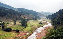
Geography
Neighboring districts are (from the south clockwise) Bo Kluea, Pua and Thung Chang. To the north and east is Xaignabouli Province of Laos with an international border crossing at Huay Kon/Muang Ngeun.
The district is located in the Luang Prabang Range mountain area of the Thai highlands.
Administration
The district is subdivided into 2 subdistricts (tambon), which are further subdivided into 22 villages (muban). There are no municipal (thesaban) areas, and 2 Tambon administrative organizations (TAO).