
Time zone CET (UTC+1) Area 50.98 km² Population 195 (2011) | Website www.civljane.hr Local time Wednesday 2:53 PM | |
 | ||
Weather 11°C, Wind NE at 35 km/h, 50% Humidity | ||
Cetina (Serbian Cyrillic: Цетина) is a small village which is a part of Civljane municipality in Šibenik-Knin County, Croatia, with 195 inhabitants.
Contents
Map of 22310, Cetina, Croatia
Geography
Located in inland Dalmatia, north from the town of Vrlika, on the route between towns of Knin and Vrlika, Cetina village spread on 50.98 km2, on the field near the spring of river Cetina, on altitude of approximately 380 m, just under south base of mountain Dinara. Parts of a settlement are hamlets: Dolac nad Lukovačom, Dražica u Lukovači, Jarčište, Lukovača, Nad Glavicom, Nad Lukovačom, Njiva u Lukovači, Podić, Podunište, Sjenokos, Unište, Vaganac and Ždrilo.
History
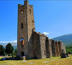
In the 9th century, probably during the time of Duke Branimir of Croatia, the old Croatian Church of Holy Salvation (Crkva Sv. Spasa) was built in the village. It is one of the oldest and best preserved monuments of the early Croatian sacral architecture.
The Serbian Orthodox Church of Holy Salvation (Hram Vaznesenja) was built in 1940 by Marko Četnik and his wife Jelena on the spring of river Cetina. The church was rebuilt in 1974.