
Topo map San Luis Obispo Elevation 398 m | Easiest route Not open to the public Age of rock 20.013271 million years Parent range Santa Lucia Range | |
 | ||
Similar Chumash Peak, Hollister Peak, Cerro Cabrillo, Cerro San Luis Obispo, Bishop Peak | ||
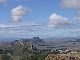
Cerro Romualdo is a 1,300-foot (396 m) hill in San Luis Obispo County, California. The hill is the fifth in a series of volcanic plugs called the Nine Sisters. Until 1964 the hill was officially known as Romualdo Peak.
Map of Cerro Romauldo, California 93405, USA
The hill is named for a Chumash man who received the 117-acre (0.47 km2) Rancho Huerta de Romualdo Mexican land grant from Pío Pico, the last Mexican Governor of Alta California. Huerta de Romualdo means Romualdo's kitchen garden or orchard in Spanish. He sold the land to Captain John Wilson in 1846.
In the 1890s, rock from Cerro Romualdo was used in the construction of the Southern Pacific Railroad.
Cerro Romualdo is owned by the State of California, and is used by the California National Guard at adjacent Camp San Luis Obispo for fitness training.