
- prominence 450 m (1,476 ft) Area 9.02 km² | Elevation 650 m Established 1956 | |
 | ||
Similar Cerro El Baúl, Riscos de Momostenango, El Rosario National Park, Las Victorias, Grutas de Lanquín | ||
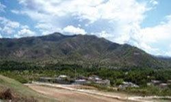
Cerro Miramundo, also known as Montaña de la Soledad, is a hill covered with dry shrubland located a few kilometers south of the city of Zacapa in Guatemala. The hill represents a panoramic point with an impressive view over the surrounding landscape.
Map of Cerro Miramundo, Guatemala
An area of 9.02 km² was declared a national park in 1956.
References
Cerro Miramundo Wikipedia(Text) CC BY-SA