
Time zone Central (CST) (UTC-6) Zip code 53012 | State Wisconsin Elevation 784 ft (239 m) Area code(s) 262 Population 11,475 (2013) | |
 | ||
Weather 14°C, Wind SW at 23 km/h, 81% Humidity Points of interest Cedar Creek Park, Wisconsin Museum of Quilts & F, Cedarburg Art Museum, 1849 Kuhefuss House M, General Store Museum | ||
Cedarburg is a city in Ozaukee County, Wisconsin, United States. It is located about 20 miles (32 km) north of Milwaukee and near the shores of Lake Michigan. The city is bordered by the village of Grafton to the east and the Town of Cedarburg elsewhere. The population was 11,412 at the 2010 census.
Contents
- Map of Cedarburg WI USA
- A walk in cedarburg wisconsin jan 9 2014
- History
- Tourism
- Geography
- Demographics
- 2010 census
- Public schools
- Parochial schools
- Attractions
- References
Map of Cedarburg, WI, USA
A walk in cedarburg wisconsin jan 9 2014
History
The first person to settle in the area was Joseph Gardenier, who built a log shanty on Cedar Creek, in what is now Hamilton. The shanty was his headquarters for surveying for the construction of the Green Bay Road. William Ludwig Groth (Ludwig Groth) is usually credited with being the first settler. He purchased land from the government on October 22, 1842, and began platting the banks of Cedar Creek. Frederick August Leuning, who immigrated to the area in 1843, built a cabin near Cedar Creek on what was later the east end of the city. He called the cabin "Cedarburg", which meant "the castle of cedars". Soon afterwards, he built the Columbia Mill on that site. In December 1844 it was agreed that the town be named Cedarburg. Groth envisioned a village along Cedar Creek and parceled out his land for those who would in the future build businesses and settle permanently. Groth eventually included all of north Cedarburg, everything above the interurban tracks to Bridge St. and from 3rd St. to Jefferson Ave. His untimely death in 1850 kept him from continuing land developments.
In 1845, Frederick Hilgen and William Schroeder saw what Groth had envisioned. After writing to Hilgen's brother-in-law, C. Frederick Boerner, they found financing for further development. Boerner loaned Hilgen and Schroeder thousands of dollars at half the going rate to develop the village of Cedarburg. They had built a gristmill on Cedar Creek. After eleven years of operation, they replaced the original structure with the five-story, stone Cedarburg Mill, which became the focal point of the new community. Five dams and mills were eventually built along the creek in what are now the city and town of Cedarburg. The Hilgen Spring Park, begun in 1854, was a 74-acre (300,000 m2) resort, that attracted visitors from all over the Midwest.
The Cedarburg Woolen Mill was founded in 1864 what in 1842 had been Groth's temporary brush house made of branches for protection from weather and wild beasts. By 1893, it was the largest woolen mill west of Philadelphia. In 1897, a generator was installed, producing the first electricity in the town. In 1901, the city contracted an electric plant with steam engines running two 75 kW generators, and in 1909 the Cedarburg Electric Light Commission was formed to run the utility. In 1923, responsibility for water and sewerage was given to the utility, and it was renamed the Light & Water Commission. The utility is still in business today, and is one of 82 municipally owned electric utilities in Wisconsin.
Tourism
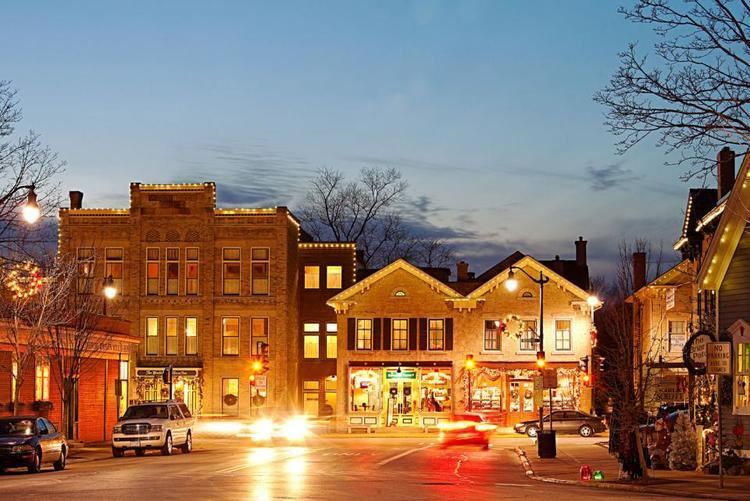
The woolen mill closed in 1968 and sat vacant for several years, until an offer was made to buy the buildings. The prospective owner intended to tear them down and build a gas station and a mini-mart. Then mayor, Stephan Fischer, told him he would need a demolition permit. There was no such thing, but it bought enough time that the buildings could be saved. William Welty bought the buildings on the corner and street, opening a restaurant. Jim Pape then bought the mill buildings on the creekside, opening a winery. Known as the Cedar Creek Settlement, the rest of the space was rented out to shops, studios and restaurants.
This began a tourism boom in Cedarburg. As the city became a quaint and pleasant place to visit, more galleries and studios opened, as well as souvenir shops and other attractions. Business associations started weekend festivals, which attracted even more people to the city. In the summer months, local companies sponsor a concert series called Summer Sounds which takes place at Cedar Creek Park.
Since 1974, many buildings in the city of Cedarburg have been added to the National Register of Historic Places (NRHP). The individual sites, combined with the Historic Districts, include 216 buildings.
Geography
Cedarburg is located at 43°17'56" North, 87°59'13" West (43.29896, -87.987209). Cedar Creek runs through the city.
According to the United States Census Bureau, the city has a total area of 4.87 square miles (12.61 km2), of which, 4.83 square miles (12.51 km2) of it is land and 0.04 square miles (0.10 km2) is water. Several sites in Cedarburg are on the Environmental Protection Agency's Superfund National Priorities List of hazardous waste sites.
Demographics
As of 2000, the median income for a household in the city was $56,431, and the median income for a family was $66,932. Males had a median income of $51,647 versus $30,979 for females. The per capita income for the city was $27,455. About 1.8% of families and 2.7% of the population were below the poverty line, including 3.0% of those under age 18 and 3.6% of those age 65 or over.
2010 census
As of the census of 2010, there were 11,412 people, 4,691 households, and 3,060 families residing in the city. The population density was 2,362.7 inhabitants per square mile (912.2/km2). There were 4,916 housing units at an average density of 1,017.8 per square mile (393.0/km2). The racial makeup of the city was 96.3% White, 0.8% African American, 0.1% Native American, 1.5% Asian, 0.3% from other races, and 1.0% from two or more races. Hispanic or Latino of any race were 1.7% of the population.
There were 4,691 households of which 31.0% had children under the age of 18 living with them, 54.1% were married couples living together, 8.5% had a female householder with no husband present, 2.6% had a male householder with no wife present, and 34.8% were non-families. 30.3% of all households were made up of individuals and 13% had someone living alone who was 65 years of age or older. The average household size was 2.38 and the average family size was 3.00.
The median age in the city was 43.1 years. 24.7% of residents were under the age of 18; 6.5% were between the ages of 18 and 24; 22% were from 25 to 44; 30% were from 45 to 64; and 16.9% were 65 years of age or older. The gender makeup of the city was 47.4% male and 52.6% female.