
County San Luis Obispo FIPS code 06-12132 Elevation 23 m Zip code 93430 Area code Area code 805 | State California Time zone Pacific (PST) (UTC-8) GNIS feature IDs 1656455, 2407994 Area 9.005 km² Population 2,592 (2010) | |
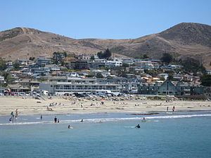 | ||
Cayucos is a census-designated place located on the coast in San Luis Obispo County, California along California State Route 1 between Cambria to the north and Morro Bay to the south. The population was 2,592 at the 2010 census, down from 2,943 at the 2000 census.
Contents
Map of Cayucos, CA 93430, USA
History
Prehistorically the local area was inhabited by the Chumash people, who settled the coastal San Luis Obispo area approximately 11,000 to 10,000 BC, including a large village to the south of Cayucos at Morro Creek.
The first European land exploration of Alta California, the Spanish Portolà expedition, camped in the vicinity of today's Cayucos on September 9, 1769. Coming from the previous campsite near Morro Bay, Franciscan missionary and expedition member Juan Crespi noted in his diary that "In the four hours that we traveled, making at the most three leagues, we encountered eight arroyos by which the water from the mountains runs to the sea, along whose edge we traveled. We halted at the eighth watering place in a moderately broad valley, into which enters an estuary fed by an arroyo of good water coming from the mountains." Crespi translator Herbert Bolton noted the camp location as Ellysley Creek (further along the coast to the northwest), but the description sounds more like Cayucos.
Cayucos is the Hispanicization of a Chumash word for "kayak," or "canoe," used by the Chumash people to fish in the bay, particularly in the rich kelp beds just north of the current Cayucos pier. The town took its name from the old Rancho Moro y Cayucos, a Mexican land grant awarded in 1842 that includes the present area of the town.
In 1867, Captain James Cass settled on 320 acres (1.29 km2) of this land, and founded the town of Cayucos. Cass began developing the area with his business partner, Captain Ingals. Cass built a 900-foot pier and a warehouse to house cargo bound for San Francisco or Los Angeles. Eventually Cass returned to life on the sea and in 1875 real estate developer C.H. Phillips subdivided and sold the remaining portions of Rancho Moro y Cayucos. The original pier was swept away by a storm but has since been rebuilt.
On December 7, 1987, Pacific Southwest Airlines Flight 1771, bound from Los Angeles International Airport to San Francisco, was cruising above the central California coast when a recently terminated disgruntled USAir employee aboard the plane shot his ex-supervisor, both pilots, a flight attendant and presumably PSA's chief pilot, causing the airplane to enter a steep nosedive. The aircraft slammed into a hillside just east of Cayucos at 770 mph (1,239 km/h). All 43 passengers and crew aboard perished.
In October 2009, Arthur Frommer's Budget Travel Magazine listed Cayucos as one of the "Coolest Small Towns in America".
Geography
Cayucos is located at 35°26′18″N 120°53′26″W (35.438390, -120.890647).
According to the United States Census Bureau, the CDP has a total area of 3.5 square miles (9.1 km2), of which, 3.1 square miles (8.0 km2) of it is land and 0.4 square miles (1.0 km2) of it (10.85%) is water.
Cayucos is home to Cayucos State Beach.
2010
The 2010 United States Census reported that Cayucos had a population of 2,592. The population density was 745.4 people per square mile (287.8/km²). The racial makeup of Cayucos was 2,366 (91.3%) White, 6 (0.2%) African American, 12 (0.5%) Native American, 54 (2.1%) Asian, 8 (0.3%) Pacific Islander, 57 (2.2%) from other races, and 89 (3.4%) from two or more races. Hispanic or Latino of any race were 207 persons (8.0%).
The Census reported that 2,592 people (100% of the population) lived in households, 0 (0%) lived in non-institutionalized group quarters, and 0 (0%) were institutionalized.
There were 1,314 households, out of which 214 (16.3%) had children under the age of 18 living in them, 578 (44.0%) were opposite-sex married couples living together, 105 (8.0%) had a female householder with no husband present, 45 (3.4%) had a male householder with no wife present. There were 76 (5.8%) unmarried opposite-sex partnerships, and 10 (0.8%) same-sex married couples or partnerships. 471 households (35.8%) were made up of individuals and 195 (14.8%) had someone living alone who was 65 years of age or older. The average household size was 1.97. There were 728 families (55.4% of all households); the average family size was 2.53.
The population was spread out with 337 people (13.0%) under the age of 18, 169 people (6.5%) aged 18 to 24, 488 people (18.8%) aged 25 to 44, 946 people (36.5%) aged 45 to 64, and 652 people (25.2%) who were 65 years of age or older. The median age was 53.0 years. For every 100 females there were 91.9 males. For every 100 females age 18 and over, there were 93.2 males.
There were 2,354 housing units at an average density of 677.0 per square mile (261.4/km²), of which 781 (59.4%) were owner-occupied, and 533 (40.6%) were occupied by renters. The homeowner vacancy rate was 4.6%; the rental vacancy rate was 12.8%. 1,555 people (60.0% of the population) lived in owner-occupied housing units and 1,037 people (40.0%) lived in rental housing units.
2000
As of the census of 2000, there were 2,943 people, 1,405 households, and 809 families residing in the CDP. The population density was 954.4 people per square mile (368.9/km²). There were 2,284 housing units at an average density of 740.7 per square mile (286.3/km²). The racial makeup of the CDP was 93.82% White, 6.80% Hispanic or Latino (of any race), 2.17% from two or more races, 2.11% from other races, 1.26% Asian, 0.37% Native American, 0.24% African American, and 0.03% Pacific Islander.
There were 1,405 households out of which 19.6% had children under the age of 18 living with them, 46.4% were married couples living together, 7.5% had a female householder with no husband present, and 42.4% were non-families. 33.6% of all households were made up of individuals and 13.2% had someone living alone who was 65 years of age or older. The average household size was 2.08 and the average family size was 2.62.
In the CDP, the population was spread out with 16.8% under the age of 18, 6.5% from 18 to 24, 24.4% from 25 to 44, 28.7% from 45 to 64, and 23.5% who were 65 years of age or older. The median age was 46 years. For every 100 females there were 91.7 males. For every 100 females age 18 and over, there were 91.1 males.
The median income for a household in the CDP was $42,841, and the median income for a family was $53,594. Males had a median income of $35,333 versus $31,359 for females. The per capita income for the CDP was $26,525. About 2.4% of families and 8.2% of the population were below the poverty line, including 7.1% of those under age 18 and 4.0% of those age 65 or over.
Government
In the California State Legislature, Cayucos is in the 17th State Senate District and the 35th Assembly District.
In the United States House of Representatives, Cayucos is in California's 24th congressional district, represented by Democrat Salud Carbajal.