
Population 23,885 (2011 census) Unitary authority Country England Area 6.64 km² Dialling code 0118 UK parliament constituency Reading East | OS grid reference SU7174 Region South East Sovereign state United Kingdom Post town Reading Ceremonial county Berkshire | |
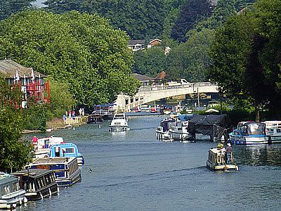 | ||
Caversham is a suburb in the Borough of Reading, a unitary authority, in the royal, non-administrative county of Berkshire, England. Caversham occupies much of the land of a geographically large village of the same name founded in the Middle Ages. It lies on the north bank of the River Thames, opposite the rest of Reading. Caversham Bridge, Reading Bridge and Caversham Lock (pedestrians only) provide crossing points, with Sonning Bridge also available a few miles east of Caversham.
Contents
Map of Caversham, Reading, UK
Caversham has at Caversham Court foundations of a medieval house, a herb garden and tree-lined park open to the public at no charge, Caversham Lakes and marking its south and south-east border the Thames Path National Trail.
Caversham extends from the River Thames flood plain to just south of the Chilterns. Its named neighbourhoods are arbitrary divisions, as green space is scattered throughout and forms an outlying buffer zone. These are Emmer Green (on postal district and on historic boundaries), Lower Caversham or Caversham (town/proper), Caversham Heights and Caversham Park Village (which is closer to the centre of Emmer Green than the main amenities or high street of Caversham). With the exception of the centre of Caversham and Emmer Green, which were traditional villages, most of the development occurred during the 20th century.
At the 2011 census the proportion of homes that were rented as opposed to owned was close to 50% of the average for the borough. The area had 15.3% of Reading's population and 16.4% of the borough's area. In keeping with a suburb, in 2005 ONS land use statistics published with the census, Caversham had 4.3% of the non-domestic buildings. Almost wholly low rise where developed, its homes occupied 20.6% of the footprint of all homes in the borough.
History
The name of Caversham in 1066 was Caveham. The first written description of Caversham as Cavesham appeared in the Domesday Book within the hundred of Binfield. This entry indicates that a sizeable community had developed with a considerable amount of land under cultivation.
Some time before 1106 a Shrine of Our Lady was established in Caversham. Its precise location is unknown, but it may have been near the present St Peter's Church. It became a popular place of pilgrimage, along with the chapel of St. Anne on the bridge and her well, whose waters were believed to have healing properties. By the 15th century the statue was plated in silver; Catherine of Aragon is recorded as visiting on 17 July 1532. The shrine was destroyed on 14 September 1538 under the orders of Henry VIII. Only the well survives, now dry and surrounded by a protective wall, topped with a domed iron grill. A modern shrine to Our Lady has been re-established at the Roman Catholic Church of Our Lady and St. Anne.
In the Middle Ages Caversham Manor was one of the demesnes of William Marshal (1146 or 47 – 1219), Earl of Pembroke and regent during King Henry III's minority. It was the place of his death.
The medieval community was clustered on the north side of Caversham Bridge east of St. Peter's Church, which was built in the 12th century. The third Earl of Buckingham donated the land for the church and neighbouring rectory, together with a considerable amount of land around it, to the Augustinian Abbey of Notley near Long Crendon in Buckinghamshire. After the Dissolution of the Monasteries, these lands were given to Christ Church, Oxford. The rectory stood in what is now Caversham Court park and herb garden where there are remains with information panels and flat foundation stones as well as a ha ha wall below giving a view over the River Thames and much of Reading and Tilehurst.
In the Civil War there was fierce fighting around Caversham Bridge for a short time in April 1643. Reading had been held by Royalists and was besieged by a Parliamentary force under the Earl of Essex. Royalists marched south from Oxford to try to relieve the town's defenders but were heavily defeated, and the town fell to the Parliamentarians a few days later.
The fortified manor house was replaced by Caversham House and Park in the 16th century. Several houses have stood on the site, notably the home of William Cadogan, 1st Earl Cadogan. The present Caversham Park House, built in 1850, is occupied by BBC Monitoring, which is a section of the BBC World Service that analyses news, information and comment gathered from mass media around the world. It is also the premises of the BBC Written Archives Centre and BBC Radio Berkshire. The BBC announced in July 2016 that it planned to leave the site and transfer its operations elsewhere.
Caversham was an urban district and part of Oxfordshire until 9 November 1911, when it was transferred to Berkshire and became part of the county borough of Reading.
Government
Caversham is entirely within the borough of Reading and forms four of the borough's sixteen electoral wards: Caversham, Peppard, Mapledurham and Thames wards. Two of Caversham's wards derive their names from Oxfordshire villages that are outside the borough boundary – Mapledurham and Rotherfield Peppard.
Caversham is in the Reading East parliamentary constituency, currently represented by Rob Wilson of the Conservative Party. The 2016 Boundary Commission review recommends moving one of Caversham's wards, Mapledurham, into the Reading West constituency.
Education
There is one local authority secondary school in Caversham, Highdown School. Many children from the area also attend Chiltern Edge School in South Oxfordshire. In the independent sector, Queen Anne's School educates girls between the ages of 11 and 18 while Hemdean House School has mixed infants and junior schools, and a girls senior school.
There are several primary schools in Caversham including Caversham Primary School, Caversham Park Primary School, Emmer Green Primary School, The Hill Primary School, St. Anne's RC Primary School, St. Martin's RC Primary School, Micklands Primary School and Thameside Primary School.
There is a shortage of primary school places in the west of Caversham, but a 2006 proposal to use part of Mapledurham playing fields to build a replacement for Caversham Primary School did not receive public support. A new Heights Primary School, took its first pupils in September 2014 in temporary accommodation, but the search for a permanent site for the school generated controversy. The Education Funding Authority (EFA) acquired a site (previously residential) in Upper Warren Avenue during 2014, but there was criticism of the choice from local residents. After representations from affected constituents, the local MP, Rob Wilson, intervened. Following discussions with the EFA, Reading Borough Council was commissioned to work with local stakeholders on alternative sites. Five possibilities were proposed – two parks, a wildlife site, a residential site and a field in adjoining Oxfordshire. The subsequent consultation showed a clear preference for sacrificing part of Mapledurham playing fields. The consultation is not binding, and there remain significant legal difficulties in overturning the terms of the trust conditions applying to the land. It is in trust for recreation purposes and was gifted by the late Mr Hewett to residents of Mapledurham and Reading.
Reading Borough Council made the following statements on Mapledurham Playing Fields:- http://readingplay.co.uk/documents%5Ccouncillors%5Ccommittee%5Cdecisionbooks/14796/330.pdf READING BOROUGH COUNCIL DECISION BOOK SEPTEMBER 3 2010
3.2 Mapledurham Playing Fields is an area of open space held in trust by the Council for the benefit of residents of Reading. As an area of public open space, the site plays an important role in addressing some of the key themes of the Cultural Strategy, including Access, Health, Learning, Creativity, Social Inclusion, Diversity, Environmental and Economic Sustainability.
3.3 Reading’s Open Space Strategy includes a number of objectives designed to protect and improve the choice and quality of open space accessible to all.
5.0 The City 2020 Vision sees Reading as the premier centre for the performing arts, leisure and sport in the Thames Valley, and providing the highest range of leisure, educational, cultural and sporting facilities for all its residents, businesses and visitors. Parks and open spaces contribute to this vision by providing free access to a wide range of water and land-based recreational activities in a uniquely beautiful location.
5.1.1 Being mostly free to use and open every day, parks are particularly important to people with limited income and limited open space at home. There is little barrier to use, whether by ethnic origin, social background, 3 physical or financial means. Consequently, parks and open spaces in general are the most frequented Council service in which people make a choice as to whether to use or not.
5.2.1 Parks and open spaces are a key contributor to a sustainable and healthy environment whilst encouraging an active and healthy lifestyle of those participating.
5.2.2 Well designed and well maintained public open spaces contribute to social well being and help reduce the fear of crime.
5.3.1 The object of the Charity is to provide and maintain a recreation ground for the benefit of residents of Mapledurham and the Borough of Reading. Enhancements to the landscape that broaden the experience of walkers and people seeking more passive recreation is within the scope of and furthers the intention of this object.
7.1 The Mapledurham Playing Fields are one of the Council’s charitable holdings, and the Council is the Trustee of the Mapledurham Playing Fields charity. The Playing Fields are held under a Charitable Trust, the object of which is for the provision and maintenance of a recreation ground for the benefits of the inhabitants of the Parish of Mapledurham and the Borough of Reading.
7.2 The function of Trustee is exercised by the Cabinet of Reading Borough Council.
7.4 As Trustee, the Council must maintain the playing fields as a recreation ground.
Caversham has several nursery schools, one of which, New Bridge Nursery school was assessed by OFSTED in 2011 as outstanding.
Chiltern College, once a training school for childminders, now provides training in all aspects of child care, and claims to be the only childcare training college in the UK with its own nurseries, school, training college and residential accommodation on campus.
Religion
There are 13 churches in the Caversham area, including five along the main road that runs through Caversham's centre. St Peter's Church is the parish church of central Caversham, with St. John's, St Andrew's and St. Barnabas making up the other Anglican Churches. Our Lady and St. Anne's is the Catholic church and the Methodists have two churches, one on the junction of Gosbrook Road and Ardler Road and one in Caversham Heights. The Baptists are represented in the centre of Caversham at Caversham Baptist Church, and also have premises in Caversham Heights. Grace Church Caversham meets at Caversham Hill Chapel, and is part of Newfrontiers, and The New Testament Church of God (Pentecostal) meets in Caversham's old cinema. Caversham Park Village Church meets in Caversham Park Primary School each Sunday and is an ecumenical project made up of Anglicans, Baptists and Methodists. Finally, Caversham Evangelical Church meets at the Youth and Community Centre in Emmer Green.
Topography
The shopping area and immediate residential surrounds that form Central Caversham are surrounded by more recent developments that form bolt-on additions to the suburb: Caversham Heights on the higher ground to the west, Lower Caversham to the south east, and Caversham Park Village to the north east on what was the parkland of Caversham Park. Emmer Green, to the north, is an older village but is generally considered part of Caversham.
Elevations of homes vary from 37m above mean sea level to 92m at the top of Caversham Park, three metres short of the highest point in the east of the area. The bank of the river has the Thames Path National Trail except to the west of Caversham, where it reverses banks at Reading Bridge. Between Mapledurham on the Thames and Caversham Heights, adjoining their respective golf courses is a western narrow outcrop of the northern foothills that reaches 95m AOD. The low Chiltern Hills on the north bank of the River Thames are therefore higher than the land on the opposite bank, providing wide views to the south.
Sport
Caversham AFC is one of the largest youth football clubs in the area with many of the girls and boys youth teams competing in the top divisions of local leagues. Caversham AFC's main ground is Clayfield Copse, commonly referred to as "Swan's Lair" because the mascot for the team is a swan. In previous seasons, Highdown School has been used as Caversham AFC's training ground. The club colours are red and black.
The Albert Road recreation ground offers facilities for tennis, croquet, and bowls.
Demography
Caversham including Emmer Green (the north bank) had: 22.1% of its homes being socially or privately rented in 2011, whereas the borough had 42.4%. This broad area had 20.4% of Reading's population and 23.5% of the borough, with the north bank's homes occupying 29.1% of the footprint of the whole borough's homes. It had 5.7% of the borough's non-domestic buildings footprint.
The same figures (where Emmer Green is excluded from analysis) are that Caversham more narrowly defined, as is becoming more common, saw 24.8% of its homes rented against the borough's 42.4%, the same area had 15.3% of Reading's population and 16.4% of the borough's area with its homes occupying 20.6% of the footprint of the whole borough's homes. It had 4.3% of the borough's non-domestic buildings footprint.