
Country Philippines Barangay ZIP code 6006 Province Cebu | District 5th district of Cebu Time zone PST (UTC+8) Area 109.6 km² | |
 | ||
Region Central Visayas (Region VII) Neighborhoods Macaas, Panalipan, Corazon, Catmondaan | ||
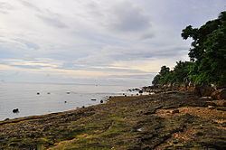
Catmon beach km 50 km 51 catmon cebu philippines
Catmon is a 4th municipal income class municipality in the province of Cebu, Philippines. According to the 2015 census, it has a population of 30,471. In the 2016 electoral roll, it had 17,150 registered voters.
Contents
- Catmon beach km 50 km 51 catmon cebu philippines
- Map of Catmon Cebu Philippines
- Esoy hot spring catmon cebu city philippines heading to the falls
- Barangays
- Demographics
- References
Map of Catmon, Cebu, Philippines
It is located along the coast of the Camotes Sea, 57 km (35 mi) north of Cebu City. Bounded on the north by Sogod; on the south by Carmen; on the west by Tuburan; and on the east by Camotes Sea, Catmon's topography is generally mountainous and hilly but patches of flat lands can be found along the coastline and portion of the poblacion.
The municipality's climate is of Coronas climate type IV, where rainfall is evenly distributed throughout the year.
Mount Capayas (Kapayas) (also known as Tore Peak), Cebu's second highest peak, is located in Cambangkaya. Mount Capayas is one of the Key Biodiversity Areas (KBAs) of Cebu.
The municipality got its name from the presence of huge trees called katmon (dillenia philippinensis) that thrive in this area.
Esoy hot spring catmon cebu city philippines heading to the falls
Barangays
Catmon comprises 20 barangays:
Demographics
In the 2016 electoral roll, it had 17,150 registered voters, meaning that 56% of the population are aged 18 and over.