
Area codes 415/628 Zip code 94109 | Area 25 ha | |
 | ||
Restaurants Tommy's Joynt, Round Table Pizza, Burger King Hotels Oasis Inn, Rodeway Inn Civic Center, Cathedral Hill Hotel, Red Roof Inn Hotel | ||
Cathedral Hill is a neighborhood and a hill, in the Western Addition district of San Francisco, California.
Contents
Map of Cathedral Hill, San Francisco, CA 94109, USA
Location
The neighborhood's northern border is Post Street, the eastern border is Van Ness Avenue, the southern border is Eddy Street and the western border is Laguna Street.
Attractions and characteristics
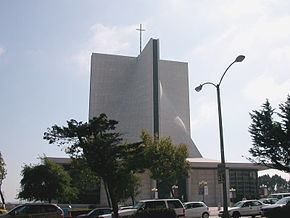
The neighborhood is centered on St. Mary's Cathedral on the corner of Geary Street and Gough Street.
It is home to large condominium and apartment towers with numerous churches built atop the hill, including St. Mary's Cathedral, St. Mark's Lutheran Church, The First Unitarian Church of San Francisco, and the Hamilton Baptist Church.
The Sacred Heart Cathedral Prep school is in the neighborhood.
References
Cathedral Hill, San Francisco Wikipedia(Text) CC BY-SA