
OS grid reference ST253835 Sovereign state United Kingdom Local time Monday 11:23 AM | Country Wales Postcode district CF3 Dialling code 1633 | |
 | ||
Weather 7°C, Wind W at 16 km/h, 82% Humidity | ||
Castleton (Welsh: Cas-bach) is a small hamlet in the city of Newport, South Wales.
Contents
Map of Castleton, Cardiff, UK
Location
Castleton is located in the Marshfield ward, an affluent region to the west of the city of Newport, also near St Mellons. The A48 dual carriageway is the main road through the hamlet.
Amenities
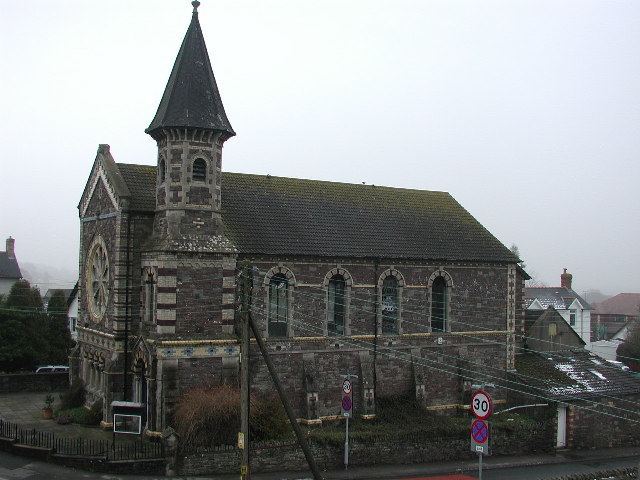
Castleton has a large, prominent Baptist chapel. It was at the Castleton Baptist Association meeting in 1816 that it was resolved to build the first Welsh Baptist Chapel in Newport, and the land then acquired in Charles Street, with the help of a bequest from John Williams, a Newport tailor.
Across the road, is a pub/restaurant, the Coach and Horses, on the A48.
Transport
The A48 dual carriageway is the main road through the hamlet. The A48(M) motorway passes close to the north of the village. There are no motorway junctions on this short link between (M4) Junction 29 and Junction 29A at St Mellons.
The Great Western Railway station at nearby Marshfield acted as a rail connection, eastwards to Newport and onwards through the Severn Tunnel, terminating at London Paddington, and westwards to Cardiff and Fishguard and Goodwick. Now closed since 1959, even long before The Beeching Report of March 1963 took effect, the nearest rail stations are in central Newport and Rogerstone.