
Prominence 70 ft (21 m) Elevation 968 m | Mountain type Erosional remnant | |
 | ||
Similar Gypsum Hills, Red Hills, Mount Sunflower | ||
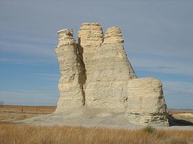
Castle Rock is a large limestone pillar landmark in Gove County, Kansas. The formation and the nearby badlands are located in the Smoky Hills region of Kansas, which is approximately 11 miles south of I-70 near Quinter, Kansas.
Contents
Map of Castle Rock, Larrabee, KS 67752, USA
Description
Castle Rock was a landmark on the Butterfield Overland Despatch route (Overland Trail). The chalk was deposited in the area by an ancient inland sea. The formation was formed by the weathering of the chalk by wind and water. It received its name because it is said to look like a castle rising above the prairie.
Weathering of the rock formation is increasing due to visitors climbing on the rocks. In 2001, following a thunderstorm, the tallest spire fell.
On January 29, 2008, Castle Rock and Monument Rocks 31 miles to the west were jointly named as one of the 8 Wonders of Kansas.