
Elevation 305 m (1,001 ft) Time zone CET (UTC+1) Local time Monday 8:41 AM Dialling code 0737 | Demonym(s) Castelraimondesi Area 44.9 km² Postal code 62022 | |
 | ||
Frazioni Crispiero, Castel S.Maria, Rustano, Brondoleto, Collina, S.Angelo, Carsignano Weather 10°C, Wind W at 24 km/h, 78% Humidity | ||
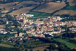
Castelraimondo is a comune (municipality) in the Province of Macerata in the Italian region Marche, located about 60 kilometres (37 mi) southwest of Ancona and about 35 kilometres (22 mi) southwest of Macerata.
Map of 62022 Castelraimondo, Province of Macerata, Italy
Castelraimondo borders the following municipalities: Camerino, Fiuminata, Gagliole, Matelica, Pioraco, San Severino Marche, Serrapetrona. The main sights is the Cassero, a watchtower built by the Da Varano lords of Camerino in medieval times.
The town contains the following churches:
References
Castelraimondo Wikipedia(Text) CC BY-SA