
Topo map NTS 82O/04 Elevation 2,998 m First ascent 1887 Mountain range Vermilion Range | Easiest route Scramble Prominence 938 m Province Alberta Parent range Vermilion Range | |
 | ||
Similar Mount Rundle, Mount Cory, Sulphur Mountain, Mt Norquay, Tunnel Mountain | ||
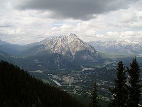
Cascade Mountain is a mountain located in the Bow River Valley of Banff National Park, adjacent to the town of Banff. The mountain was named in 1858 by James Hector after the waterfall or cascade on the southern flanks of the peak. The mountain has also been called Stoney Chief, which is related to the name of the smaller neighbouring mountain Stoney Squaw, which is still in use. Cascade is the highest mountain adjacent to the townsite.
Contents
Map of Cascade Mountain, Improvement District No. 9, AB, Canada
Climbing routes
The mountain can be climbed starting from the Norquay Ski Area base. The first portion is a fairly moderate hike, up to the Cascade Amphitheatre. Continuing upwards, the route ascends along the ridge edge until it reaches the crest where it dips before it rises to the false summit. While the false summit can be descended at its end, it is much easier to follow a trail around the western side along the exposed foot. Snow typically blocks this route almost until mid July and attempting it while snowy can entail considerable avalanche risk due to the slabby terrain and exposure. A long window of clear weather - full day - should be anticipated before attempting this climb, as many climbers have gotten into trouble and needed rescue (or died) when a storm suddenly blows in. The ascent normally takes 3 to 4 hours while the descent along the same path takes 2 to 3 hours.