
Country Colombia Region Caribbean Founded by Pedro de Heredia | Department Bolívar Foundation June 1, 1533 Elevation 2 m (7 ft) | |
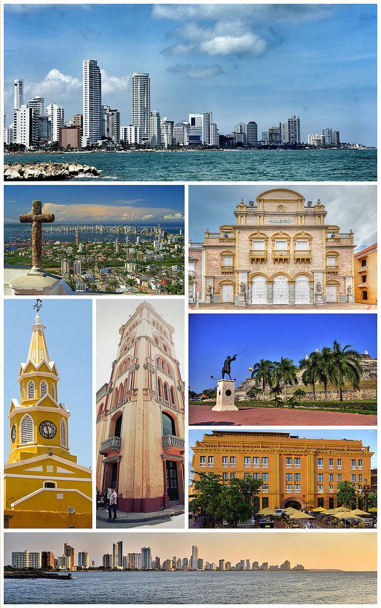 | ||
The city of Cartagena, Cartagena de Indias in Spanish ([kartaˈxena ðe ˈindjas]), is a port located on the northern coast of Colombia in the Caribbean Coast Region; it is the capital of the Bolívar Department, and had a population 971,592 as of 2016. It is the fifth-largest city in Colombia and the second largest in the region, after Barranquilla. The urban area of Cartagena is also the fifth-largest urban area in the country. Economic activities include the maritime and petrochemicals industries, as well as tourism.
Contents
- Map of Cartagena Bolivar Colombia
- Pre Columbian era 4000 BC 1500 AD
- First sightings by Europeans 15001533
- Colonial era 15331717
- Viceregal era 17171811
- 1741 attack
- Silver Age 17501808
- 1811 to the 21st century
- Location
- Neighborhoods
- Northern area
- Downtown
- San Diego
- Getseman
- Bocagrande
- Climate
- Industry
- Miss Colombia
- Free zones
- Tourism
- Transportation
- Roads
- Air
- Sea
- Canals
- Waste disposal
- Colleges and universities
- Primary and secondary schools
- Libraries
- Theatres and concert halls
- Sport
- Museums and galleries
- World Heritage site
- Festivities
- Film
- Television
- Literature
- Video games
- 19th century
- 20th century
- References
Map of Cartagena, Bolivar, Colombia
The city was founded on June 1, 1533, and named after Cartagena, Spain, which in turn was named after Carthage in Tunisia. Settlement in the region around Cartagena Bay by various indigenous people dates back to 4000 BC. During the Spanish colonial period Cartagena served a key role in administration and expansion of the Spanish empire. It was a center of political and economic activity due to the presence of royalty and wealthy viceroys. In 1984, Cartagena's colonial walled city and fortress were designated a UNESCO World Heritage Site.
Pre-Columbian era: 4000 BC – 1500 AD
The Puerto Hormiga Culture, found in the Caribbean coast region, particularly in the area from the Sinú River Delta to the Cartagena Bay, appears to be the first documented human community in what is now Colombia. Archaeologists estimate that around 4000 BC, the formative culture was located near the boundary between the present-day departments of Bolívar and Sucre. In this area, archaeologists have found the most ancient ceramic objects of the Americas, dating from around 4000 BC. The primary reason for the proliferation of primitive societies in this area is thought to have been the relative mildness of climate and the abundance of wildlife, which allowed the hunting inhabitants a comfortable life.
Archaeological investigations date the decline of the Puerto Hormiga culture and its related settlements to around 3000 BC. The rise of a much more developed culture, the Monsú, who lived at the end of the Dique Canal near today's Cartagena neighborhoods Pasacaballos and Ciénaga Honda at the northernmost part of Barú Island, has been hypothesized. The Monsú culture appears to have inherited the Puerto Hormiga culture's use of the art of pottery and also to have developed a mixed economy of agriculture and basic manufacture. The Monsú people's diet was based mostly on shellfish and fresh and salt-water fish.
The development of the Sinú society in what is today the departments of Córdoba and Sucre, eclipsed these first developments around the Cartagena Bay area. Until the Spanish colonization, many cultures derived from the Karib, Malibu and Arawak language families lived along the Colombian Caribbean coast. In the late pre-Columbian era, the Sierra Nevada de Santa Marta was home to the Tayrona people, whose language was closely related to the Chibcha language family.
Around 1500 the area was inhabited by different tribes of the Karib language family, more precisely the Mocanae sub-family, including:
Some subsidiary tribes of the Kalamari lived in today's neighborhood of Pie de la Popa, and other subsidiaries from the Cospique lived in the Membrillal and Pasacaballos areas. Among these, according to the earliest documents available, the Kalamari had preeminence. These tribes, though physically and administratively separated, shared a common architecture, such as hut structures consisting of circular rooms with tall roofs, which were surrounded by defensive wooden palisades.
First sightings by Europeans: 1500–1533
After the failed effort to find Antigua del Darién in 1506 by Alonso de Ojeda and the subsequent unsuccessful founding of San Sebastián de Urabá in 1517 by Diego de Nicuesa, the southern Caribbean coast became unattractive to colonizers. They preferred the better known Hispaniola and Cuba.
Though the Casa de Contratación gave permission to Rodrigo de Bastidas (1460–1527) to again conduct an expedition as adelantado to this area, Bastidas explored the coast and discovered the Magdalena River Delta in his first journey from Guajira to the south in 1527, a trip that ended in the Gulf of Urabá, the location of the failed first settlements. De Nicuesa and De Ojeda noted the existence of a big bay on the way from Santo Domingo to Urabá and the Panama isthmus, and that encouraged Bastidas to investigate.
Colonial era: 1533–1717
Cartagena was founded on June 1, 1533 by the Spanish commander, Pedro de Heredia, in the former location of the indigenous Caribbean Calamarí village. The town was named after Cartagena, Spain, where most of Heredia's sailors had resided. The city first was settled by 200 Spanish immigrants in 1533, and during the remainder of the 16th century there was rapid population growth. A major attraction was the gold found in the tombs of the Sinú Culture. After those tombs were completely plundered, the inhabitants began to scatter to the countryside and to establish themselves as farmers, and the population of the city decreased.
A little later, the city had fewer than 2000 inhabitants and one church; the dramatically increasing fame and wealth of the prosperous city turned it into an attractive plunder site for pirates and corsairs–French and English privateers licensed by their king. Thirty years after its founding, the city was pillaged by the French nobleman Jean-François Roberval. The city set about strengthening its defenses and surrounding itself with walled compounds and castles. Pirate Martin Cote attacked years later. A few months after the disaster of the invasion of Cote, a fire destroyed the city and forced the creation of a firefighting squad, the first in the Americas.
In 1568, Sir John Hawkins of England tried to trick Governor Martín de las Alas into violating Spanish law by opening a foreign fair in the city to sell goods, which would have allowed Hawkins to ravage the port afterwards; the governor declined. Hawkins besieged the city, but failed to level it.
After this disaster, Spain poured millions every year into the city for its protection, beginning with Gov. Francisco de Murga's planning of the walls and forts; this practice was called Situado. The magnitude of this subsidy is shown by comparison: between 1751 and 1810, the city received the sum of 20,912,677 Spanish reales. The city recovered quickly from Drake's attack and subsequent occupation, and continued its growth and hence its inevitable attraction for predators, including a large group of pirates who attacked in late 1683. Nonetheless, trade began to increase, continuing into the 17th century. The city reached the peak of its development in 1698 before the arrival of the Baron de Pointis.
The Raid on Cartagena in 1697 by Sir Bernard Desjean, Baron de Pointis and Jean Baptiste Ducasse was an all-out invasion that was politically motivated. Absent a male successor to the Spanish Habsburg throne, King Louis XIV wanted his grandson Felipe V to assert the right of succession, and conquering Cartagena could help significantly. The political purpose behind the invasion was somewhat undermined by Ducasse, the governor of Saint-Domingue (today's Haiti), who brought his soldiers with an intent on thievery, but the invasions ended with pirates and thieves destroying the city. Entry to the city was hindered by the recently finished first stage of walls and forts, and the invasion was costly. While Desjean had asked for 250,000 Spanish reales in ransom, Ducasse stayed but a few months and did not honor the baron's promise to respect the churches and holy places. Ducasse left the inhabitants with nothing.
During the 17th century, the Spanish Crown paid for the services of prominent European military engineers to construct fortresses; today these are Cartagena's most significant identifiable features. Engineering works took well over 200 years, and ended with some 11 kilometres (6.8 mi) of walls surrounding the city, including the Castillo San Felipe de Barajas named in honor of Spain's King Philip IV. The Castillo was built during the governorship of Pedro Zapata de Mendoza, Marquis of Barajas and was constructed to repel land attacks: it included buildings for food and weapons storage, and was equipped with sentry boxes and underground tunnels connecting the fortifications. The original fort was constructed between 1639 and 1657 on top of San Lazaro Hill; in 1762 extensive expansion was undertaken, and the final result is the current bastion. Numerous attempts to storm the reinforced fort were mounted, but it was never penetrated.
Cartagena was a major trading port, especially for precious metals. Gold and silver from the mines in the New Granada and Peru were loaded in Cartagena on the galleons bound for Spain via Havana. Cartagena was also a slave port; Cartagena and Veracruz, (Mexico), were the only cities authorized to trade African slaves. The first slaves were transported by Pedro de Heredia, and were used as cane cutters (allowing the new inhabitants to open roads), as laborers to destroy the tombs of the aboriginal population of Sinú, and to construct buildings and fortresses. The agents of the Portuguese company Cacheu sold slaves from Cartagena for working in mines in Venezuela, the West Indies, the Nuevo Reino de Granada and the Viceroyalty of Perú.
On February 5, 1610, the Catholic Monarchs established aInquisition Holy Office Court in Cartagena by a royal decree issued by King Philip II; with Lima in Peru, it was one of the three seats of the Inquisition in the Americas. The Palace of Inquisition, finished in 1770, preserves its original features of colonial times. When Cartagena declared its complete independence from Spain on November 11, 1811, the inquisitors were urged to leave the city. The Inquisition operated again after the Reconquest in 1815, but it disappeared entirely when Spain surrendered six years later to the troops led by Simón Bolívar.
The census conducted by the mayor's office in 1712 reflected the damage wrought on the city by Jean Baptiste Ducasse and his forces: a major portion of the population of the city had emigrated.
Viceregal era: 1717–1811
Although the 18th century began very badly for the city, soon things began to improve. The pro-trade economic policies of the new dynasty in Madrid bolstered the economics of Cartagena, and the establishment of the Viceroyalty of the New Granada in 1717 placed the city in the position of being the greatest beneficiary of the colony. The 18th century brought the Bourbon dynasty and its pro-trade policies, and these benefited the city, returning it to prosperity again. During this period, the city passed the psychological barrier of 18,000 inhabitants, which was at the time the population cap of the Viceroyalty of New Granada.
The reconstruction after the Raid on Cartagena (1697) was initially slow, but with the end of the War of the Spanish Succession around 1711 and the competent administration of Juan Díaz de Torrezar Pimienta, the walls were rebuilt, the forts reorganized and restored, and the public services and buildings reopened. By 1710, the city was fully recovered. At the same time, the slow but steady reforms of the restricted trade policies in the Spanish Empire encouraged the establishment of new trade houses and private projects. During the reign of Philip V of Spain the city had many new public works projects either begun or completed, among them the new fort of San Fernando, the Hospital of the Obra Pía and the full paving of all the streets and the opening of new roads.
1741 attack
In March 1741, the city endured a large-scale attack by British and American colonial troops led by Admiral Edward Vernon (1684–1757), who arrived at Cartagena with a massive fleet of 186 ships and 23,600 men, including 12,000 infantry, against six Spanish ships and fewer than 3,000 men, in an action known as the Battle of Cartagena, part of the War of Jenkin's Ear. The siege was broken off due to the start of the tropical rainy season, after weeks of intense fighting in which the Spanish and native forces successfully repelled the British landing party. Commander General Blas de Lezo y Olavarrieta, a Basque from the Guipuzcoa province in northern Spain led the Spanish forces, but died in the aftermath of the battle.
Heavy British casualties were compounded by diseases such as yellow fever. This victory prolonged Spain's control of the Caribbean waters, which helped secure its large Empire until the 19th century. Admiral Vernon was accompanied by American Colonial troops, including George Washington's brother, Lawrence Washington, who was so impressed with Vernon that he named his Mount Vernon estate and plantation after him.
Silver Age (1750–1808)
After Vernon, what is called the 'Silver Age' of the city (1750–1808) began. This time was one of permanent expansion of the existing buildings, massive immigration from all the other cities of the Viceroyalty, increase of the economic and political power of the city and a population growth spurt not equaled since that time. Political power that was already shifting from Bogotá to the coast completed its relocation, and the Viceroys decided to reside in Cartagena permanently. The inhabitants of the city were the richest of the colony, the aristocracy erected noble houses on their lands to form great estates, libraries and printing establishments were opened, and the first café in New Granada was even established. The good times of steady progress and advancement in the second half of the 18th century came to an abrupt end in 1808 with the general crisis of the Spanish Empire that came from the Mutiny of Aranjuez and all its consequences.
Among the censuses of the 18th century was the special Census of 1778, imposed by the governor of the time, D. Juan de Torrezar Diaz Pimienta – later Viceroy of New Granada – by order of the Marquis of Ensenada, Minister of Finance – so that he would be provided numbers for his Catastro tax project, which imposed a universal property tax he believed would contribute to the economy while at the same time increasing royal revenues dramatically. The Census of 1778, besides having significance for economic history, is interesting because each house had to be described in detail and its occupants enumerated, making the census an important tool The census revealed what Ensenada had hoped. However, his enemies in the court convinced King Charles III to oppose the tax plan.
1811 to the 21st century
For more than 275 years, Cartagena was under Spanish rule. On November 11, 1811, Cartagena declared its independence. It had been the biggest city of the Viceroyalty until 1811, when the Peninsular War, which became Wars of Independence and Piñeres's Revolts, marked the beginning of a dramatic decline in all aspects for what had become the virtual capital of New Granada. In 1815 the city was almost destroyed. No census information exists for that time. There are accounts of how the city became a ghost town. Around 500 impoverished freed slaves dwelt the city, whose palaces and public buildings became ruins, many with collapsed walls.
By mid-1815 a large Spanish expeditionary fleet under Pablo Morillo had arrived in New Granada and forces besieged Cartagena. After a five-month siege the fortified city fell on December 1815. By 1816, the combined efforts of Spanish and colonial forces, marching south from Cartagena and north from royalist strongholds in Quito, Pasto, and Popayán, completed the reconquest of New Granada, taking Bogotá on May 6, 1816.
In 1821 the general Mariano Montilla conducted the pivotal siege of Cartagena assisted by naval forces under José Prudencio Padilla. The city fell on October 10, 1821 after a siege lasting 159 days. Among the defenders who surrendered was Brigadier Gabriel Torres, commander of the royalist forces. The patriots captured large stores of gunpowder, lead, rifles and field pieces.
Location
Cartagena faces the Caribbean Sea to the west. To the south is the Cartagena Bay, which has two entrances: Bocachica (Small Mouth) in the south, and Bocagrande (Big Mouth) in the north. Cartagena is located at 10°25' North, 75°32' West (10.41667, −75.5333).
Neighborhoods
The metropolitan area of Cartagena is formed by:
Northern area
In this area is the Rafael Núñez International Airport, located in the neighborhood of Crespo, ten minutes' drive from downtown or the old part of the city and fifteen minutes away from the modern area. Zona Norte, the area located immediately north of the airport contains the Hotel Las Americas, the urban development office of Barcelona de Indias, and several educational institutions.
Downtown
The Downtown area of Cartagena has varied architecture, mainly a colonial style, but republican and Italian style buildings, such as the Cathedral's bell tower, can be seen.
The main entrance to downtown is the Puerta del Reloj (Clock Gate), which exits onto the Plaza de los Coches (Square of the Carriages). A few steps farther is the Plaza de la Aduana (Customs Square), next to the mayor's office. Nearby is San Pedro Claver Square and the church also named for Saint Peter Claver, where the body of the Jesuit saint ('Saint of the African slaves') is kept in a casket, as well as the Museum of Modern Art.
Nearby is the Plaza de Bolívar (Bolívar's Square) and the Palace of Inquisition. Plaza de Bolívar (formerly known as Plaza de La Inquisicion) is essentially a small park with a statue of Simón Bolívar in the center. This plaza is surrounded by balconied colonial buildings. Shaded outdoor cafes line the street.
The Office of Historical Archives devoted to Cartagena's history is not far away. Next to the archives is the Government Palace, the office building of the Governor of the Department of Bolivar. Across from the palace is the Cathedral of Cartagena, which dates back to the 16th century.
Another religious building of significance is the Iglesia de Santo Domingo in front of Plaza Santo Domingo (Santo Domingo Square). In the square is the sculpture Mujer Reclinada ("Reclining Woman"), a gift from the notable Colombian artist Fernando Botero. Nearby is the Tcherassi Hotel, a 250-year-old colonial mansion renovated by designer Silvia Tcherassi.
In the city is the Augustinian Fathers Convent and the University of Cartagena. This university is a center of higher education opened to the public in the late 19th century. The Claustro de Santa Teresa (Saint Theresa Cloister), which has been remodeled and has become a hotel operated by Charleston Hotels. It has its own square, protected by the San Francisco Bastion.
A 20-minute walk from downtown is the Castillo de San Felipe de Barajas, located in el Pie de la Popa (another neighborhood), the greatest fortress ever built by the Spaniards in their colonies. The tunnels were all constructed in such a way as to make it possible to hear footsteps of an approaching enemy. Some of the tunnels are open for viewing today.
San Diego
San Diego was named after the local San Diego Convent, now known as the Beaux Arts University Building. In front of it is the Convent of the Nuns of the Order of Saint Clare, now the Hotel Santa Clara. In the surrounding area is Santo Toribio Church, the last church built in the Walled City. Next to it is Fernández de Madrid Square, honoring Cartagena's hero, José Fernández de Madrid, whose statue can be seen nearby.
Inside the Old City is found Las Bóvedas (The Vaults), a construction attached to the walls of the Santa Catalina Fortress. From the top of this construction the Caribbean Sea is visible.
Getsemaní
Once a district characterized by crime, Getsemani, just south of the ancient walled fortress, has become "Cartagena's hippest neighborhood and one of Latin America's newest hotspots", with plazas that were once the scene of drug dealing being reclaimed and old buildings being turned into boutique hotels.
Bocagrande
The Bocagrande (Big Mouth) is an area known for its skyscrapers. The area contains the bulk of the city's tourist facilities, such as hotels, shops, restaurants, nightclubs and art galleries. It is located between Cartagena Bay to the east and the Caribbean Sea to the west, and includes the two neighborhoods of El Laguito (The Little Lake) and Castillogrande (Big Castle). Bocagrande has long beaches and much commercial activity is found along Avenida San Martín (Saint Martin Avenue).
The beaches of Bocagrande, lying along the northern shore, are made of volcanic sand, which is slightly grayish in color. This makes the water appear muddy, though it is not. There are breakwaters about every 200 yards (180 m).
On the bay side of the peninsula of Bocagrande is a seawalk. In the center of the bay is a statue of the Virgin Mary. The Naval Base is also located in Bocagrande, looking at the Bay.
Climate
Cartagena features a tropical wet and dry climate. Humidity averages around 90%, with rainy seasons typically in May–June and October–November. The climate tends to be hot and windy.
Industry
Other prominent companies include Cementos Argos, Miss Colombia, Kola Román, Indufrial, Amazon Pepper, Vikings SA, Distribuidora Ltda Refrigeration, Central Ingenio Colombia, Perfumery Lemaitre, Cartagena Refinery Cellux Colombiana SA, Flour Three Castles, Polyban International SA, SABMiller, Dow Chemical, Cemex, Dole, and Abocol..
Miss Colombia
In 1934, Miss Colombia was founded in Cartagena de Indias. Known as Concurso Nacional de Belleza de Colombia (National Beauty Contest of Colombia), it is a national beauty pageant in Colombia. The winner, Señorita Colombia, is sent to Miss Universe and the first runner-up, Señorita Colombia Internacional or Virreina, to Miss International.
Free zones
Free zones are areas within the local territory which enjoy special customs and tax rules. They are intended to promote the industrialization of goods and provision of services aimed primarily at foreign markets and also the domestic market.
Tourism
Tourism is a mainstay of the economy. The following are tourist sites within the city:
Transportation
As the commercial and touristic hub of the country, the city has many transportation facilities, particularly in the seaport, air, and fluvial areas.
In 2003, the city started building Transcaribe, a mass transit system. In 2015 the system began operating in the city
Roads
The city is linked to the northern part of the Caribbean Region through roads 90 and 90A, more commonly called Central Caribbean Road. This Road passes through Barranquilla, Santa Marta and Riohacha ending in Paraguachón, Venezuela and continues with Venezuelan numeration all the way to Caracas. Taxis in the city perimeter do not have fare meters.
The following roads are in the southeast portion of the city:
Road 25: Going through Turbaco and Arjona, and through the Montes de María when a fork divides it continuing to Sincelejo as National 25 and finally ending in Medellín, and to the east to Valledupar as number 80.
Road 25 A: Going also to Sincelejo, but avoiding the mountains, connects with Road 25 in the forementioned city.
Air
The Rafael Núñez International Airport, is the busiest airport in Colombia's Caribbean region and the fourth in passenger traffic in the country. The code of the airport is CTG, having flights to almost all airports in Colombia including Bogota's Eldorado International Airport. Excessive operational costs and easier connection travel and better prices had led to the shifting of the Rafael Núñez's international connection passengers away from Bogota to the nearer Tocumen International Airport in Panama and Queen Beatrix International Airport in Aruba. Also more companies prefer to serve the Colombian market from Cartagena, due to better geographical and atmospheric conditions.
Sea
The open ports of the City are:
Of the private ports of the city:
Canals
Since the 17th century the bay has been connected to the Magdalena River by the Dique Canal, built by Governor Pedro Zapata de Mendoza. After Colombian independence, the canal was abandoned. Increasing centralization left the city without resources to maintain it. The last important maintenance work was done in the 1950s during Laureano Gómez's administration. Some improvements were made by local authorities in the 1980s. This was discontinued because of legal objections from the central government that decreed that the "maintenance" of the canal did not fall under the jurisdiction of the local government. From then on, maintenance of the canal has been delayed, though it is still functional.
Cartagenian political leaders have argued that this state of affairs might change with a return to pre-independence funding and tax system. Under such systems the canal would be maintained properly and even expanded, benefiting the national economy.
Waste disposal
Cartagena is one of the few cities in the world with a submarine emissary inaugurated in 2013. The emissary is the third largest in the world.
Colleges and universities
Primary and secondary schools
International schools include:
Libraries
The city has many public and private libraries:
Theatres and concert halls
The first carnivals and western theaters that served in New Granada operated on, what is today, Calle del Coliseo. This was an activity patronized by the Viceroy Manuel de Guirior and Antonio Caballero y Góngora, who, like their predecessors, spent most of the time of their mandates ruling in Cartagena.
Sport
The main football club in the city is Real Cartagena.
Museums and galleries
World Heritage site
The port, the fortresses and the group of monuments of Cartagena were selected in 1984 by the United Nations Educational, Scientific and Cultural Organization (UNESCO) as significant to the heritage of the world, having the most extensive fortifications in South America. They are significant, too, for being located in a bay that is part of the Caribbean Sea. A system of zones divides the city into three neighborhoods: San Sebastian and Santa Catalina with the cathedral and many palaces where the wealthy lived and the main government buildings functioned; San Diego or Santo Toribio, where merchants and the middle class lived; and Getsemani, the suburban popular quarters.