
Population 1,532 (2011) Country Wales Postcode district SA70 Local time Friday 3:39 AM Post town Tenby | OS grid reference SN045038 Sovereign state United Kingdom Police Dyfed-Powys Dialling code 01646 Principal area Pembrokeshire | |
 | ||
Weather 7°C, Wind SE at 19 km/h, 92% Humidity | ||
Carew (Welsh: Caeriw) is a village and community on an inlet of Milford Haven in the former Hundred of Narberth, Pembrokeshire, West Wales, 7 km east of Pembroke. The eastern part of the parish is included in the Pembrokeshire Coast National Park.
Contents
Map of Carew, Tenby, UK
Description
The meaning of the name is disputed. It is Welsh and could mean "fort on a hill" (Caer-rhiw), "fort by yews" (Caer-yw) or simply "forts" (Caerau). It is pronounced /'kε:ru/, or more traditionally /'kε:ri/. The village grew up to serve the nearby Norman castle. The parish includes several other villages and hamlets, including Carew Cheriton (around the parish church), Milton, Newton, West Williamston, Sageston and Whitehill.
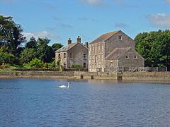
Textile mills gave Milton its name. In the 19th century there was a carding mill downstream, a weaving mill by the bridge, and a fulling mill upstream.
West Williamston has an almost-disappeared industrial history. Limestone was quarried in the area for centuries. The stone was cut from slot-shaped flooded quarries communicating with the haven, known locally as "docks". See examples at 51°42′29″N 4°50′35″W. These allowed stone to be dropped from the quarry faces directly into barges at the bottom. From there, stone was shipped to lime kilns all around the coast of North Pembrokeshire and Cardiganshire. A small inland quarry still operates just north of Carew village. Besides limestone, anthracite was mined on a small scale for local consumption at Minnis Pit on the northeastern edge of the parish.
Typical of South Pembrokeshire, the parish has been predominantly English-speaking since the 12th century.
Features
MARGIT
EUT.RE
X.ETG.FILIUS
Local Government
The village has its own elected community council and gives its name to an electoral ward of Pembrokeshire County Council.