
Population 5,779 (2011 census) Area 3.8 km² Parish Kahibah | Postcode(s) 2285 Postal code 2285 | |
 | ||
State electorate(s) Lake MacquarieWallsendCharlestown | ||
Cardiff is a suburb of the City of Lake Macquarie, New South Wales, Australia. It is located 13 kilometres (8 mi) west-southwest of Newcastle's central business district in the City of Lake Macquarie North Ward.
Contents
- Map of Cardiff NSW 2285 Australia
- History
- Education
- Population statistics
- Place of birth
- Main language spoken at home
- Religion
- Shopping
- Sporting clubs
- Car Sales
- Industrial Estate
- Railway
- References
Map of Cardiff NSW 2285, Australia
An irregularly shaped suburb, Cardiff is home to two government primary schools, a Catholic primary school and a government high school. Like most major suburbs in Lake Macquarie, it has its own commercial centre with a post office, pub (hotel), real estate agencies, take-away shops, a video store, tattoo studio, two opportunity stores, numerous hairdressers and two supermarkets.
The local police station no longer provides counter services, having been converted into a centre for Highway Patrol officers in around 1998.
History
The first grant to a white settler in the Cardiff area was a parcel of 2,560 acres (10.4 km2) to George Weller in 1833, stretching west of the current Macquarie Road to Argenton and Cockle Creek.
Other selections were taken up by individual settlers from 1862 to the east of the Weller grant. The locality became known as Winding Creek after the stream which wound its way from south-east to north-west across the central valley of the area.
In the latter part of the 19th Century two factors attracted people to the Winding Creek area.
One was coal mining, with the Lymington (1882) and South Wallsend (1884, later renamed Cardiff) collieries both starting production in the vicinity of the current Cardiff South.
The other was the decision to construct the Sydney to Newcastle railway, which led to a navvies camp being established at Winding Creek in 1883, and work continuing through most of the rest of the decade.
The line originally ran close to current Myall Rd, however the gradient from Cardiff up to Tickhole Tunnel proved too steep for the trains of the period, and the line was relocated to the present position a few years after it was opened.
For a short period in the 1880s Lymington became the popular name for the whole Cardiff area, supplanting Winding Creek, however it fell foul of the postal authorities, because of its similarity to another, established locality name. There were a number of Welsh settlers living in the area, and on the suggestion of one of them, James Edwards, the name Cardiff was chosen after the capital of Wales. It was officially adopted in 1889.
Education
The suburb is home to two government primary schools; Cardiff Public School and Cardiff North Public School, a government secondary school; Cardiff High School, and a catholic primary school; St. Kevin's Primary School.
Population statistics
Australian Bureau of Statistics data from the 2001 census records the population of Cardiff as 5,039 residents, with a gender mix of 49% males and 51% females in line with the rest of the Australian population. (Australian Bureau of Statistics, 2002)
Place of birth
Main language spoken at home
Religion
Shopping
Cardiff has a small shopping centre, as well as numerous small specialty stores. There are two supermarkets; an Aldi store, as well as a Woolworths supermarket.
The Woolworths shopping centre features a liquor store, newsagency, bakery, Subway, sushi cafe, hairdresser, travel agency, as well as a Woolworths supermarket.
Sporting clubs
Cardiff has sporting clubs for the following sports:
Car Sales
The suburb is home to a large number of car dealerships, including:
The suburb is also home to a number of used car dealerships.
Industrial Estate
Cardiff is a major employment area thanks to the Cardiff Industrial Estate, which is the highest employing area in the Hunter region.
Around half of that industrial estate is accessible only via one section of Munibung Road, a 2-lane road between two T-intersections (Torrens Avenue and Mitchell Road) which experience frequent crashes. The intersection of Munibung Road with Macquarie Road and Myall Road is the main access point for the entire industrial estate and suffers from some of the most severe congestion in the Hunter Region.
A proposal exists for the extension of Pennant Street over the railway line to a roundabout connecting to Main Road near Glendale Drive and to the end of Stockland Drive inside the Stockland Glendale shopping centre. The proposal also includes the construction of a new railway station for access to the industrial estate and the Glendale shopping centre. The proposal is ready to proceed but has been awaiting state government funding for several years.
A further proposal exists for the extension of Munibung Road through the redeveloped former Pasminco Sulphide site, connecting through the new light industrial and residential development to T C Frith Avenue in Boolaroo. It is hoped that the developer will fund that road as part of that development.
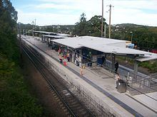
Railway
The main northern railway line passes through Cardiff to the north of the industrial estate and commercial centre. Cardiff railway station is located on Main Road up a steep hill from the commercial centre.
The railway station has a single island platform, which is located between the two tracks. Access to the platform is only available via a staircase that is exposed to the weather and difficult for elderly residents to negotiate. After two decades of petitioning by locals, funding from State Government was allocated to upgrade the railway station. The upgrade will include the installation of lifts and extending the existing platform to accommodate for eight-car trains. The upgrade of the train station commenced mid-2012 and it is expected to be completed by late 2013.
Two carparks are provided on the southern side of the railway station. A small carpark is located directly alongside the southbound track, while a larger carpark is located down another steep staircase.