
Isolation 7.44 mi (11.98 km) First ascent 1909 | Elevation 4,307 m Prominence 527 m | |
 | ||
Listing North America highest peaks 52ndUS highest major peaks 38thColorado highest major peaks 19thColorado fourteeners 29th Topo map USGS 7.5' topographic mapCapitol Peak, Colorado Easiest route Northeast "Knife" Ridge: exposed Scramble, class 4 First ascenders Harold Clark, Percy Hagerman Similar Snowmass Mountain, Elk Mountains, Pyramid Peak, Castle Peak, Crestone Peak | ||
Capitol Peak is a high and prominent mountain summit in the Elk Mountains range of the Rocky Mountains of North America. The 14,137-foot (4,309 m) fourteener is located in the Maroon Bells-Snowmass Wilderness of White River National Forest, 8.7 miles (14.0 km) east by south (bearing 104°) of the community of Redstone in Pitkin County, Colorado, United States.
Contents
Map of Capitol Peak, Colorado 81654, USA
MountainEdit
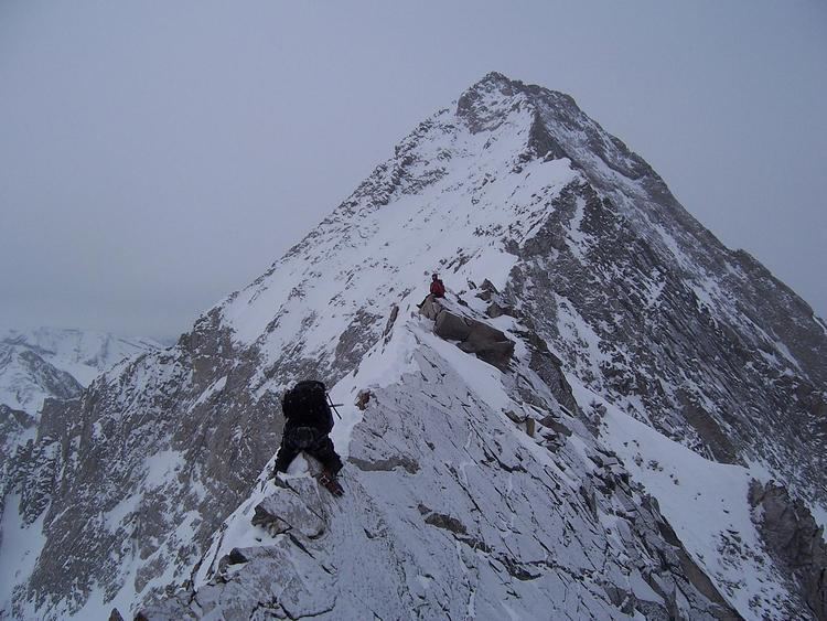
Capitol Peak lies on the long ridge connecting the heart of the Elk Mountains with Mount Sopris to the northwest. Capitol Peak is notable for its impressive vertical relief, rising nearly 9,000 feet above the Roaring Fork Valley.
Capitol Peak is one of the most difficult of Colorado's fourteeners to climb. The only non-technical route, the Northeast Ridge, requires crossing the famously exposed "Knife Edge," the northeast ridge of Capitol. Fatalities have occurred on this route. Other routes require technical rock climbing, for example, the Northwest Buttress Route (Grade IV, Class 5.9). These routes have significant rockfall danger due to a great deal of loose rock; however, the rock is substantially more solid than on the more famous Maroon Bells or on Pyramid Peak.