
Year first constructed 1910s Foundation concrete Height 16 m Focal height 17 m | Year first lit 9th November 1928 Construction metal skeletal tower Opened 9 November 1928 Automated 1928 | |
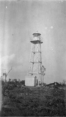 | ||
Location Clarence StraitNorthern TerritoryAustralia Tower shape square pyramidal tower with balcony and lantern Similar Emery Point Light, Cape Don Light, East Vernon Light, Point Charles Light, Top End | ||
Cape Hotham Light is an active lighthouse located on Cape Hotham, which is on the shore of the Timor Sea on a long unnamed peninsula about 80 kilometres (50 mi) northeast of Darwin, Northern Territory, Australia. The lighthouse marks the entrance to Clarence Strait, the eastern approach to Darwin.
The lighthouse was constructed by the Commonwealth Lighthouse Service during the "Golden Age of Australian Lighthouses", between 1913 and 1920.
The light characteristic shown is three flashes, one every two seconds, repeating every 15 seconds (Fl.(3)W.R. 15s). The color is red on 025°-070° and white elsewhere. The red light is visible for 9 nautical miles (17 km; 10 mi) while the white light is visible for 12 nautical miles (22 km; 14 mi).
The site is accessible by boat from Darwin, but the tower is closed to the public. The light is operated by the Australian Maritime Safety Authority.
Cape Hotham
Cape Hotham was named by John Clements Wickham on 26 July 1839, honoring Admiral William Hotham, 1st Baron Hotham. It is listed in the Register of the National Estate as the "Cape Hotham Forest Reserve", listing "representative ecosystems of the Top End, including monsoon rainforest containing kentia palm (Gronophyllum ramsayi)".