
 | ||
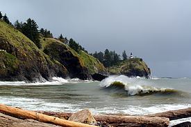
Cape Disappointment is a headland located at the extreme southwestern corner of Washington State on the north side of the Columbia River bar, at 46°16′6.13″N 124°5′3.52″W. The point of the cape is located on the Pacific Ocean in Pacific County, approximately two miles (3.2 km) southwest of the town of Ilwaco. Cape Disappointment receives about 2552 hours of fog a year – the equivalent of 106 days – making it one of the foggiest places in the US.
Map of Cape Disappointment, Washington 98624, USA
The cape was named on April 12, 1788 by British fur trader John Meares who was sailing south from Nootka in search of trade. After a storm, he turned his ship around just north of the Cape and therefore just missed the discovery of the Columbia River. George Vancouver credits John Meares in his account when he saw Cape Disappointment on April 27, 1792.
Cape Disappointment State Park is located on the cape, as is the Cape Disappointment Lighthouse. United States Coast Guard Station Cape Disappointment is situated on the river near the state park. The station crewmembers respond to 300–400 calls for assistance every year.