
Country United States Area 28.23 sq mi Mayor Lornna Soto (PNP) | Founded 1909 Population 48,068 (2011) | |
 | ||
Unemployment rate 13.9% (Dec 2014) | ||
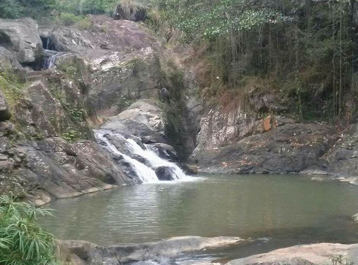
Quebrada sonadora canovanas puerto rico forest part 6
Canóvanas ([kaˈnoβanas]) is a municipality in Puerto Rico, located in the northeastern region, north of Juncos and Las Piedras; south of Loíza; east of Carolina; and west of Río Grande. Canóvanas is spread over 7 wards and Canóvanas Pueblo (The downtown area and the administrative center of the city). It is part of the San Juan-Caguas-Guaynabo Metropolitan Statistical Area.
Contents
- Quebrada sonadora canovanas puerto rico forest part 6
- Map of Canvanas Puerto Rico
- Los eucaliptos en canovanas puerto rico
- History
- Geography
- Water features
- Cityscape
- Barrios
- Area
- Tourism
- Agriculture
- Commerce
- Industrial
- Culture
- Sports
- Demographics
- Government
- Flag and coat of arms
- Nicknames
- Transportation
- Books
- References
Map of Canóvanas,-Puerto-Rico
Los eucaliptos en canovanas puerto rico
History
The region of what is now Canóvanas belonged to the Taíno region of Cayniabón, which stretched from the northeast coast of Puerto Rico into the central region of the island. The region was led by cacique Canobaná-from which the actual name is derived-, in the south half, and female Cacica Loaiza in the north (coastal portion). During the Spanish colonization, the region of Canóvanas was granted to Miguel Díaz, who turned the Taíno "yucayeque" into a ranch. It is said that Canóbana, along with Loaiza, were supporters of the Spanish regime and didn't join the Taino rebellion of 1511.
Canóvanas was a "barrio" (ward) of Loíza for over 400 years. In 1902, the Legislative Assembly of Puerto Rico approved a law for the consolidation of certain municipalities. As a result, both Canóvanas and Loíza were incorporated to the town of Río Grande. However, in 1905 a new law revoked the previous one, returning Canóvanas to its previous state as a "barrio" of Loíza.
In 1909, the Municipal administration of Loíza was transferred to the barrio of Canóvanas, which was more developed than the Loíza region. Also, the construction of the PR-3 facilitated the communication with Canóvanas. As a result of the transfer, land was acquired to build a new city hall, a town square, a slaughterhouse, and a cemetery. A 20-acre (8.1 ha) plot of land was purchased by Don Luis Hernaiz Veronne, a townhall Senator and local farmer. The site location was strategic, to intercept traffic from the PR-3, and from other nearby roads like the PR-185.
However, the transfer wasn't well received by the residents of the original City of Loíza, renamed "Loiza Aldea". It wasn't until a law was passed on June 30, 1969, that both towns were recognized as "clearly different population nuclei" recommending the establishment of two separate municipalities. The change was approved on 1970 by Governor Luis A. Ferré.
Like other nearby towns, Canóvanas' proximity to the capital, San Juan, has allowed extraordinary urban and commercial development in the region.
Geography

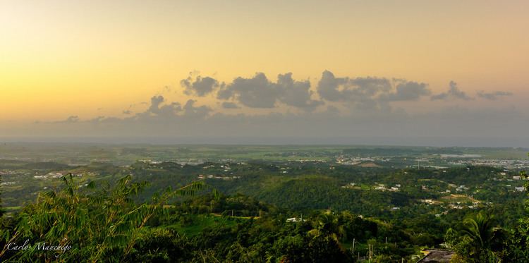
Canovanas sits on the Northern Coastal Plain region of Puerto Rico. It is bordered by the municipalities of Loíza, Río Grande, Las Piedras, Juncos, Gurabo, and Carolina. Canóvanas covers only 28 square miles (72.8 km2).
Canóvanas combines flat alluvial plains in the center and north, areas with both gentle hills and rugged, deeply dissected mountainous areas made up of volcaniclastic rocks (lava flows and exposed intrusive igneous rocks) to the southeast and south. The Cuchilla de Santa Inés, a limestone hill (mogote) with an elevation of 328 feet, rises from coastal sediments on the northeast of the city near San Isidro, while the Cuchilla El Asomante lies at the south with elevations that range from 656 to 2,296 feet.
On the southeast, Canóvanas features portions of the Luquillo Mountain Range, with the Cerro El Negro being the tallest peak in the region at 2,592 feet. Other notable peaks are La Peregrina (1,903 feet) and Pitahaya (951 feet), both located at Barrio Hato Puerco.
Water features
Much of the flat plains are part of the flood-prone alluvial valley of the Río Grande de Loíza and its main tributaries, the Río Canóvanas and Río Canovanillas. Floods are typical during the storm season, between June and November. Other important tributaries are the Río Herrera and Río Cubuy, as well as numerous creeks.
Cityscape
The urban center of Canóvanas is located along Road PR-3, historically the main road between San Juan and Fajardo.
Barrios
Canóvanas is divided into six barrios or wards.
Area
Tourism
Although Canóvanas is not particularly known for its touristic importance, there are several landmarks and places of interest to visit. The Jesús T. Piñero's house is located along the PR-3. The residence, which was built around 1931, houses a museum dedicated to the life of Jesús T. Piñero, first Puerto Rican governor of the island.
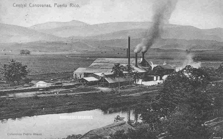
The Hipódromo Camarero is also a tourist attraction for horserace fans of the island and the Caribbean. Other places of interest are the ruins of the Canóvanas Sugar Mill, El Español Bridge, the Old Ceiba Tree, and Villarán Park.
Agriculture
The economy of Canóvanas has traditionally relied on agriculture, primarily sugarcane and coffee. There was an important sugar mill located in the PR-951 from Canóvanas to Loíza. It belonged to Loíza Sugar Company, and then to Fajardo Sugar Company. However, the mill closed in 1965. In 1999, the structure was declared of historical importance by the Legislative Assembly of Puerto Rico. There's also growth of minor vegetables and fruits, as well as a minor cattle and poultry industry. Most of Canóvanas flat areas are subject to occasional flooding and are used as pastures for cattle.
Commerce
In recent years, Canóvanas economy has shifted to commerce and industry, supplemented by the production of fresh milk. There has also been an increase in retail businesses. There are three main shopping malls, located along the PR-3 in the Canóvanas region. These malls are the location of main stores like Wal-Mart, Marshalls, and others.
Canóvanas is sometimes referred to as "The Door to the East" due to its proximity to the San Juan Metropolitan Area, and its location en route to the northeast region of Puerto Rico. Also the expansion of Route 66 has sparked new interest in Canóvanas as an industrial and commercial sector.
Industrial
The most growing sector is the industrial zone where large international pharmaceuticals like AstraZeneca, IPR Pharmaceuticals, QBD, and other manufacturing plants.
Culture
A number of cultural events take place during the year, most prominently:
Sports
Although Canóvanas has no professional sports team currently active, several of its past teams have been notable. Traditionally, local sports teams bear the nickname of "Indios". The Indios de Canóvanas, of the Baloncesto Superior Nacional, won the championship two years in a row (1983-1984) and reached the finals in 1988. Guard Angelo Cruz and center Ramón Ramos were two of the key players of the team during that era. However, the team disappeared during the 1990s. There have been movements to reestablish the team, but they've been unsuccessful.
The Indias of Canóvanas team, from the Liga de Voleibol Superior Femenino, also won a number of championships.
Canóvanas is also the location of Hipódromo Camarero, Puerto Rico's only horse racetrack. The track, which was formerly named El Nuevo Comandante was established in 1976.
Demographics
Official population records for Canóvanas start in 1980, after the municipality was officially separated from Loíza. In 30 years, the population has increased by almost 50% according to the 2010 census.
According to the 2010 Census, 61% of the population identifies themselves as White, and 21.6% as African-American. Also, 48.6% of the population identified themselves as males, and 51.4% as females. Finally, 26.7% of the population is under 18 years old. The next biggest percentage of population (21.5%) is between 35 to 49 years old.
Government
All municipalities in Puerto Rico are administered by a mayor, elected every four years. The current mayor of Canóvanas is José "Chemo" Soto, of the New Progressive Party (PNP). He was elected at the 1992 general elections making him one of the longest tenured mayors currently in the island. Soto has distinguished himself for his eccentricities in clothing, and for successfully using the urban legend of the Chupacabra to promote the city. His daughter, Lornna, also served as a member of the Senate of Puerto Rico from 2004 to 2013.
The city belongs to the Puerto Rico Senatorial district VIII, which is represented by two Senators. In 2012, Pedro A. Rodríguez and Luis Daniel Rivera were elected as District Senators. Representatives Javier Aponte Dalmau (District 38) and Ángel Bulerín (District 37) represent different regions of Canóvanas in the House of Representatives.
Flag and coat of arms
The flag of Canóvanas features a purple background with a wide yellow band across, and the town's coat of arms in the center.
The coat of arms features a shield with the same colors (purple background and a yellow band). The colors are taken from the banner of the "Hijos y Amigos Ausentes de Canóvanas". A broken chain symbolizes the separation of Canóvanas from Loíza. The crown in the middle represents the supremacy of Cacique Canobaná. The laurels are a symbol of the 23 consecutive wins achieved by the Loíza Indians basketball team, establishing a record in Puerto Rico, also represented by the basket in the middle. The rising sun, with its sixteen rays of light, indicate the sprouting of a new municipality in Puerto Rico and the number of incumbent mayors before Canóvanas was separated from Loíza.
The coat of arms also features a white banner below with the inscription "1130 1909, Canobaná del Cayniabón, 8-16 1970". The first date, November 30, 1909, is the date of the installation of the municipal seat of Loíza in Canóvanas. The second date, August 15, 1970, is the date of the official founding of Canóvanas as a separate municipality. The names of Canobaná and Cayniabón make reference to the Taíno heritage of the region. Finally, a coronet in the form of a three-tower mural crown stands above the shield.
Nicknames
Canóvanas is known by various names. It is known as the "Pueblo Valeroso" after Cacique Yuira lost her life defending the Spanish people from her own people, the Taínos. It is also known as the "City of Indians" because of its important Taíno heritage. Canóvanas is also known as the "City of Races", because of the Hipódromo Camarero, and the "Town of the Chupacabras" because of the alleged sightings of the creature, and the beliefs in it of current mayor, José Chemo Soto.
Transportation
The main road to Canóvanas is the PR-3 that crosses the municipality from east to west. Distance from the capital is roughly 15 minutes. Other roads that lead to Canóvanas are the #185 that enters between the Lomas and Hato Puerco wards, the #186 of the Cubuy ward, and the #957 of the Hato Puerco ward. Roads #874 and #188 enter the town from the north, the former at Torrecillas Alta from Carolina and the latter at Canóvanas Barrio from Loíza. In 2012, the PR-66, which starts in Carolina, was extended to lead directly into Canóvanas.
There is also a terminal for public cars in front of the town square, as well as service provided by taxis, and independent public cars.
Canovanas is reasonably close to Luis Munoz Marin International Airport in Carolina and to the San Juan ship docks.
Books
Canóvanas, Puerto Rico The Cradle of The Indians by Greg Boudonck, Translated by Maria Ruiz O'Farrill