
- elevation 4,200 ft (1,280 m) Official name Arroyo de Cantúa Country United States of America | - elevation 344 ft (105 m) Reference no. 344 | |
 | ||
- location on the northwest slope of Santa Rita Peak in the Diablo Range., San Benito County - location 4 miles south of Cantua Creek, California., Fresno County | ||
Cantua Creek, formerly in Spanish Arroyo de Cantúa, was named for José de Guadalupe Cantúa a prominent Californio Ranchero in the 19th-century Mexican era of Alta California.
Contents
Map of Cantua Creek, California, USA
The creek was formerly a tributary of the Fresno Slough, in years of very heavy winter rains.
CourseEdit
Its source on the northern slope of Santa Rita Peak in the Diablo Range, 5.9 miles southeast of Idria within San Benito County. It flows north then east into Fresno County, emerging from its Arroyo de Cantúa canyon, that divides the Big Blue Hills from the Ciervo Hills, into the western San Joaquin Valley.
Continuing toward the Fresno Slough to the northeast, but no longer reaching it, Cantua Creek ends shortly after passing under Interstate 5, 4 miles south of the census-designated place of Cantua Creek (town) and just west of the California Aqueduct.
HistoryEdit
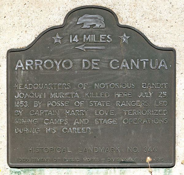
The Arroyo de Cantúa is California Historical Landmark #344, where California Rangers led by Harry Love killed notorious outlaw Joaquin Murrieta in 1853.
The 19th century Spanish and Mexican El Camino Viejo trail crossed the creek in the San Joaquin Valley.