
NRHP Reference # 97001446 Added to NRHP 10 April 1998 | Area 34 ha | |
 | ||
Location Roughly along Elmdale, Library, N. Canterbury, S. Canterbury, and Westminster Rds., Canterbury, Connecticut Architectural style Colonial, Federal, Vernacular | ||
The Canterbury Center Historic District is a historic district in Canterbury, Connecticut. It is located in the area around the junction of Route 169 (North and South Canterbury Roads) and Route 14 (Westminster Road), including properties along Elmdale and Library Roads. It was listed on the National Register of Historic Places (NRHP) in 1998.
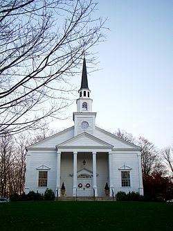
The district is centered on the town green (Canterbury Green), which was laid out in 1705 for the purpose of erecting a meeting house, although a meeting house was not constructed until 1711. The Congregational Church is located on the Green, which is surrounded by several houses dating from the late 18th to early 19th century. Among these is the Prudence Crandall House, a National Historic Landmark that is separately listed on the NRHP. The Canterbury Public Library is the only non-residential building around the Green.
The district is spread out over an area of 850 acres (340 ha) and includes 70 buildings (50 of which are contributing properties) and 2 sites.